IMAGES TAKEN NEAR TO
Back Lane, WINCHELSEA, TN36 4ET
Introduction
This page details the photographs taken nearby to Back Lane, TN36 4ET by members of the Geograph project.
The Geograph project started in 2005 with the aim of publishing, organising and preserving representative images for every square kilometre of Great Britain, Ireland and the Isle of Man.

There are currently over 7.5m images from over14,400 individuals and you can help contribute to the project by visiting https://www.geograph.org.uk
Image Map (Loading...)


Getting Data...Please wait
Leaflet Map data © OpenStreetMap
Images are licensed for reuse under creativecommons.org/licenses/by-sa/2.0
Notes
- Clicking on the map will re-center to the selected point.
- The higher the marker number, the further away the image location is from the centre of the postcode.
Image Listing (442 Images Found)
Images are licensed for reuse under creativecommons.org/licenses/by-sa/2.0
Image
Details
Distance
2
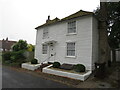
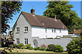
Winchelsea, Plat Cottage
Distinctive white weatherboarding, with cellar - is it one of the medieval wine cellars?
Image: © David M Clark
Taken: 23 Aug 2022
0.01 miles
3
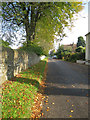
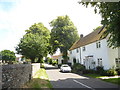
Back Lane, Winchelsea
The lane links Rectory Lane, the A259, to Rookery Lane. Originally known as Fifth Street when planned. On the right are numbers 1-2 Trojans Plat, built in 1954, and further down is Plat Cottage.
Image: © Simon Carey
Taken: 1 Jun 2019
0.01 miles
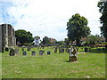
7
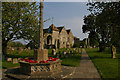
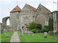
Winchelsea: St Thomas's church, war memorial and churchyard
Image: © Christopher Hilton
Taken: 24 Apr 2011
0.02 miles
9
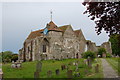
St Thomas' Church, Winchelsea, East Sussex
Image: © nick macneill
Taken: 24 Aug 2007
0.02 miles
10
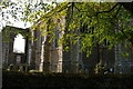
Winchelsea: St Thomas's church, east end
Image: © Christopher Hilton
Taken: 24 Apr 2011
0.02 miles