IMAGES TAKEN NEAR TO
Brede Valley View, WINCHELSEA, TN36 4DA
Introduction
This page details the photographs taken nearby to Brede Valley View, TN36 4DA by members of the Geograph project.
The Geograph project started in 2005 with the aim of publishing, organising and preserving representative images for every square kilometre of Great Britain, Ireland and the Isle of Man.

There are currently over 7.5m images from over14,400 individuals and you can help contribute to the project by visiting https://www.geograph.org.uk
Image Map
Images are licensed for reuse under creativecommons.org/licenses/by-sa/2.0
Notes
- Clicking on the map will re-center to the selected point.
- The higher the marker number, the further away the image location is from the centre of the postcode.
Image Listing (28 Images Found)
Images are licensed for reuse under creativecommons.org/licenses/by-sa/2.0
Image
Details
Distance
1
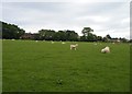
Icklesham village
Viewed from the 1066 country Walk. In the trees is a path or track which goes most of the way around the village and must mark the boundary between the tofts in infield. Most of the development is within this, but the bungalows on the right extend beyond this perimeter.
Image: © Christopher Hall
Taken: 22 May 2014
0.07 miles
2
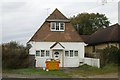
Icklesham old fire station
Icklesham old fire station, Goldhurst Green, Icklesham, Winchelsea, East Sussex was later used as the library, and now converted into a dwelling
Image: © Kevin Hale
Taken: 10 Nov 2009
0.08 miles
3
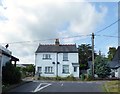
Pleasant View/St Michaels, Main Road, Icklesham
A pair of semi-detached cottages built towards the end of the 19th century.Pleasant View is on the left, St Michaels to the right.
Image: © Simon Carey
Taken: 1 Aug 2019
0.08 miles
4
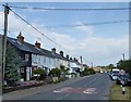
Seaview Cottages/Seaview Terrace, Main Road, Icklesham
Two sets of cottages with Seaview Cottages on the left and Seaview Terrace to the right. Both were built in the last quarter of the 19th century.
Image: © Simon Carey
Taken: 1 Aug 2019
0.09 miles
5
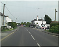
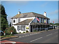
A259, heading east, passes The Robin Hood
Image: © Stuart Logan
Taken: 18 May 2013
0.09 miles
6
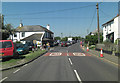
A259 passes The Robin Hood
When I write "passes" I could have substituted stops outside, because a large car boot sale in a field up the road was causing the evident tailback.
Image: © Stuart Logan
Taken: 27 May 2012
0.09 miles
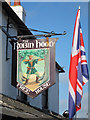
9
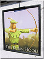
The Robin Hood sign
Image: © Oast House Archive
Taken: 21 May 2011
0.09 miles
10
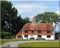
Toke Farm, Icklesham
A 16th century farmhouse now located on the western edge of the village.
Image: © Simon Carey
Taken: 1 Aug 2019
0.10 miles