IMAGES TAKEN NEAR TO
Boyne Road, HASTINGS, TN35 5NZ
Introduction
This page details the photographs taken nearby to Boyne Road, TN35 5NZ by members of the Geograph project.
The Geograph project started in 2005 with the aim of publishing, organising and preserving representative images for every square kilometre of Great Britain, Ireland and the Isle of Man.

There are currently over 7.5m images from over14,400 individuals and you can help contribute to the project by visiting https://www.geograph.org.uk
Image Map
Images are licensed for reuse under creativecommons.org/licenses/by-sa/2.0
Notes
- Clicking on the map will re-center to the selected point.
- The higher the marker number, the further away the image location is from the centre of the postcode.
Image Listing (78 Images Found)
Images are licensed for reuse under creativecommons.org/licenses/by-sa/2.0
Image
Details
Distance
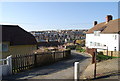
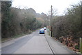
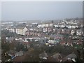
2
View of Belmont, Hastings
As seen from Barley Lane.
Image: © David Anstiss
Taken: 24 Dec 2012
0.06 miles

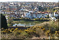
4
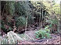
The Bourne stream between Harold Road & Boyne Road, Hastings
This photograph of the small sandrock gorge was taken before development of housing at the top of the bank on the right along Harold Road. The Bourne rises on the slopes of North's Hill and runs through Clive Vale and Belmont to the Old Town and the sea.
Image: © Patrick Roper
Taken: 5 Nov 2007
0.07 miles
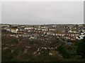
10
Ore suburbs in the fog
Looking from Barley Lane.
Image: © Oast House Archive
Taken: 3 Mar 2012
0.08 miles