IMAGES TAKEN NEAR TO
Ashburnham Road, HASTINGS, TN35 5LJ
Introduction
This page details the photographs taken nearby to Ashburnham Road, TN35 5LJ by members of the Geograph project.
The Geograph project started in 2005 with the aim of publishing, organising and preserving representative images for every square kilometre of Great Britain, Ireland and the Isle of Man.

There are currently over 7.5m images from over14,400 individuals and you can help contribute to the project by visiting https://www.geograph.org.uk
Image Map
Images are licensed for reuse under creativecommons.org/licenses/by-sa/2.0
Notes
- Clicking on the map will re-center to the selected point.
- The higher the marker number, the further away the image location is from the centre of the postcode.
Image Listing (56 Images Found)
Images are licensed for reuse under creativecommons.org/licenses/by-sa/2.0
Image
Details
Distance
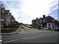
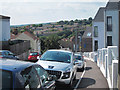
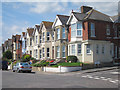
4
Ashburnham Road
Kingsnorth Power Station in the distance.
Image: © Oast House Archive
Taken: 30 Jul 2011
0.08 miles
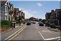
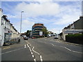
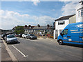
5
School Road
Recently completed houses to the right.
Image: © Oast House Archive
Taken: 30 Jul 2011
0.10 miles
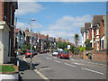
7
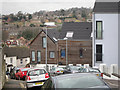
New development on School Road
A group of rendered and timber clad houses, built in 2010.
Image: © Oast House Archive
Taken: 9 Mar 2012
0.10 miles
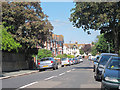
10
Construction site on Old London Road
Site of the New Clive Vale pub.
Compare with Image
Image: © Oast House Archive
Taken: 30 Jul 2011
0.11 miles