IMAGES TAKEN NEAR TO
Edmund Road, HASTINGS, TN35 5JZ
Introduction
This page details the photographs taken nearby to Edmund Road, TN35 5JZ by members of the Geograph project.
The Geograph project started in 2005 with the aim of publishing, organising and preserving representative images for every square kilometre of Great Britain, Ireland and the Isle of Man.

There are currently over 7.5m images from over14,400 individuals and you can help contribute to the project by visiting https://www.geograph.org.uk
Image Map
Images are licensed for reuse under creativecommons.org/licenses/by-sa/2.0
Notes
- Clicking on the map will re-center to the selected point.
- The higher the marker number, the further away the image location is from the centre of the postcode.
Image Listing (74 Images Found)
Images are licensed for reuse under creativecommons.org/licenses/by-sa/2.0
Image
Details
Distance
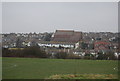
1
Githa Road
Looking from Clive Vale recreation ground.
Image: © Oast House Archive
Taken: 8 Nov 2011
0.03 miles
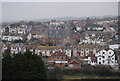
3
All Saints Church of England School, Hastings
The school is shown from the rear and entrance to it is gained from mid level.
Image: © nick macneill
Taken: 24 Feb 2012
0.05 miles
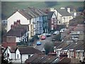
8
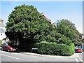
Corner of Edmund Road and Godwin Road, Hastings
Image: © Patrick Roper
Taken: 31 Jul 2007
0.09 miles
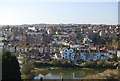
9
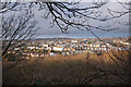
View from Rocklands Lane
Unsettled weather moving in over the town.
Rocklands Lane is a small road coming down from the open land on top of East Hill. It's part of the 1066 Country Walk.
Image: © Des Blenkinsopp
Taken: 28 Jan 2022
0.10 miles