IMAGES TAKEN NEAR TO
Tilekiln Lane, HASTINGS, TN35 5EN
Introduction
This page details the photographs taken nearby to Tilekiln Lane, TN35 5EN by members of the Geograph project.
The Geograph project started in 2005 with the aim of publishing, organising and preserving representative images for every square kilometre of Great Britain, Ireland and the Isle of Man.

There are currently over 7.5m images from over14,400 individuals and you can help contribute to the project by visiting https://www.geograph.org.uk
Image Map
Images are licensed for reuse under creativecommons.org/licenses/by-sa/2.0
Notes
- Clicking on the map will re-center to the selected point.
- The higher the marker number, the further away the image location is from the centre of the postcode.
Image Listing (15 Images Found)
Images are licensed for reuse under creativecommons.org/licenses/by-sa/2.0
Image
Details
Distance
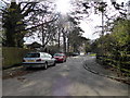
1
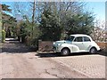
Tilekiln Lane
Unmade road and bridleway. Morris Minor saloon to right.
Image: © Oast House Archive
Taken: 4 Apr 2012
0.01 miles
2

Fairlight Road, Ore, East Sussex
Image: © Oast House Archive
Taken: 17 Oct 2008
0.08 miles
3
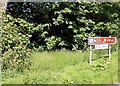
Road sign by pond at junction of Mill Lane with Fairlight Road
Image: © Patrick Roper
Taken: 13 May 2002
0.10 miles
4
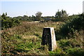
Fairlight Down trig
Part of Hastings Country Park
Image: © Iain Macaulay
Taken: 10 Oct 2005
0.10 miles
5
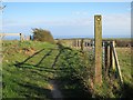
Footpath from Tilekiln Lane
Towards Barley Lane, Fairlight Glen and Hastings Country Park.
Image: © Oast House Archive
Taken: 4 Apr 2012
0.11 miles
7
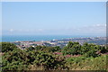
View of Hastings & Beachy head from North's Seat
View from TQ8411
Image: © Julian P Guffogg
Taken: 14 Jul 2008
0.16 miles
8
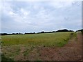
Four Acres/Tile Kiln Field
The name of the fields according to Fairlight's 1839 tithe map that have been merged to form a single unit. Four Acres was to the south adjacent to Barley Lane with Tile Kiln Field to the north.
Image: © Simon Carey
Taken: 4 Aug 2019
0.16 miles
9

Fields north of the Old Town
Looking from Limekiln Lane towards the Old Town and sea.
Image: © Oast House Archive
Taken: 4 Apr 2012
0.17 miles
10
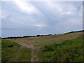
Great Meadow/Stable Meadow
The name of the fields according to Fairlight's 1839 tithe map that have been merged to form a single unit. Great Meadow was on the southern side adjacent to Barley Lane with Stable Meadow to the northeast.
Image: © Simon Carey
Taken: 4 Aug 2019
0.20 miles