IMAGES TAKEN NEAR TO
Fishponds Lane, HASTINGS, TN35 4SX
Introduction
This page details the photographs taken nearby to Fishponds Lane, TN35 4SX by members of the Geograph project.
The Geograph project started in 2005 with the aim of publishing, organising and preserving representative images for every square kilometre of Great Britain, Ireland and the Isle of Man.

There are currently over 7.5m images from over14,400 individuals and you can help contribute to the project by visiting https://www.geograph.org.uk
Image Map (Loading...)


Getting Data...Please wait
Leaflet Map data © OpenStreetMap
Images are licensed for reuse under creativecommons.org/licenses/by-sa/2.0
Notes
- Clicking on the map will re-center to the selected point.
- The higher the marker number, the further away the image location is from the centre of the postcode.
Image Listing (69 Images Found)
Images are licensed for reuse under creativecommons.org/licenses/by-sa/2.0
Image
Details
Distance
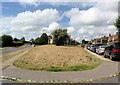
1

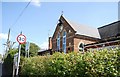
In Westfield village looking north
The road on the left is Moor Lane. The road on the right has several names according to which map one consults: Workhouse Lane, South Terrace, South Road, Moor Road. The bay window in the centre of the picture is part of Geary Place retirement home and this gives its address as Workhouse Lane.
Image: © Patrick Roper
Taken: 24 May 2022
0.12 miles
3
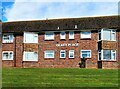
Rear of Geary Place retirement home, Westfield
Geary Place consists of 18 flats, built in 1976. It is seen here from Moor Lane, Westfield.
Image: © Patrick Roper
Taken: 24 May 2022
0.13 miles
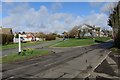
4
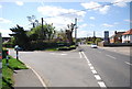
Moor Road splits, Westfield, East Sussex
Image: © nick macneill
Taken: 30 Jun 2012
0.13 miles
6
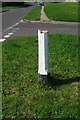
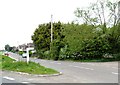
Old Direction Sign - Signpost by Moor Lane, Westfield parish
Black iron cap finial - lost, but restored 2016; East Sussex wood by the UC road, in parish of Westfield (Rother District), Moor Lane, on grass triangle at junction of Workhouse Lane with Moor Lane.
Surveyed
Milestone Society National ID: SX_TQ8115A
Image: © Milestone Society
Taken: Unknown
0.13 miles
7
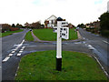
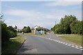
Moor Lane and Workhouse Lane
Moor Lane is to the left, Workhouse Lane to the right. Both head towards the A28.
Image: © Simon Carey
Taken: 21 Feb 2007
0.13 miles
8
Junction of Moor lane and Workhouse lane, Westfield
Image: © Julian P Guffogg
Taken: 26 Jul 2008
0.14 miles