IMAGES TAKEN NEAR TO
Main Road, HASTINGS, TN35 4SR
Introduction
This page details the photographs taken nearby to Main Road, TN35 4SR by members of the Geograph project.
The Geograph project started in 2005 with the aim of publishing, organising and preserving representative images for every square kilometre of Great Britain, Ireland and the Isle of Man.

There are currently over 7.5m images from over14,400 individuals and you can help contribute to the project by visiting https://www.geograph.org.uk
Image Map (Loading...)


Getting Data...Please wait
Leaflet Map data © OpenStreetMap
Images are licensed for reuse under creativecommons.org/licenses/by-sa/2.0
Notes
- Clicking on the map will re-center to the selected point.
- The higher the marker number, the further away the image location is from the centre of the postcode.
Image Listing (11 Images Found)
Images are licensed for reuse under creativecommons.org/licenses/by-sa/2.0
Image
Details
Distance


4

The Oast House, Main Road, Westfield
Image: © Oast House Archive
Taken: 21 Apr 2014
0.05 miles
5

The Oast House, Main Road, Westfield
Image: © Oast House Archive
Taken: 21 Apr 2014
0.05 miles

7

The Oast House, Main Road, Westfield
Image: © Oast House Archive
Taken: 16 May 2015
0.05 miles

9
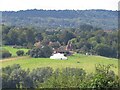
Crowham Manor
Farm complex in the north of Westfield parish, seen here from Brede Church. The marquee may imply some special event.
Image: © David M Clark
Taken: 26 Aug 2023
0.08 miles
10
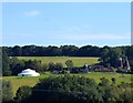
Crowham Manor Farm
Viewed across the Brede valley with Crowham Oast to the right. Not sure what the large tent is for.
Image: © Simon Carey
Taken: 16 Aug 2023
0.10 miles