IMAGES TAKEN NEAR TO
Main Road, HASTINGS, TN35 4SL
Introduction
This page details the photographs taken nearby to Main Road, TN35 4SL by members of the Geograph project.
The Geograph project started in 2005 with the aim of publishing, organising and preserving representative images for every square kilometre of Great Britain, Ireland and the Isle of Man.

There are currently over 7.5m images from over14,400 individuals and you can help contribute to the project by visiting https://www.geograph.org.uk
Image Map
Images are licensed for reuse under creativecommons.org/licenses/by-sa/2.0
Notes
- Clicking on the map will re-center to the selected point.
- The higher the marker number, the further away the image location is from the centre of the postcode.
Image Listing (35 Images Found)
Images are licensed for reuse under creativecommons.org/licenses/by-sa/2.0
Image
Details
Distance
1
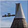
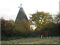
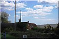
Cowl of Fuggles Oast, Main Road, Westfield, East Sussex
A Sussex blinker cowl. The vane motif depicting three lambs.
Image: © Oast House Archive
Taken: 8 Feb 2009
0.03 miles
2
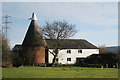
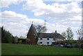
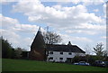
Fuggles Oast, Main Road, Westfield, East Sussex
Also see cowl close up http://www.geograph.org.uk/photo/1153349
Image: © Oast House Archive
Taken: 8 Feb 2009
0.04 miles
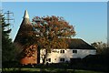
4
Downoak Farmhouse
Grade II listed. http://www.britishlistedbuildings.co.uk/en-415570-downoak-farmhouse-westfield
Image: © N Chadwick
Taken: 12 Apr 2011
0.05 miles