IMAGES TAKEN NEAR TO
New Cut, HASTINGS, TN35 4RH
Introduction
This page details the photographs taken nearby to New Cut, TN35 4RH by members of the Geograph project.
The Geograph project started in 2005 with the aim of publishing, organising and preserving representative images for every square kilometre of Great Britain, Ireland and the Isle of Man.

There are currently over 7.5m images from over14,400 individuals and you can help contribute to the project by visiting https://www.geograph.org.uk
Image Map
Images are licensed for reuse under creativecommons.org/licenses/by-sa/2.0
Notes
- Clicking on the map will re-center to the selected point.
- The higher the marker number, the further away the image location is from the centre of the postcode.
Image Listing (77 Images Found)
Images are licensed for reuse under creativecommons.org/licenses/by-sa/2.0
Image
Details
Distance
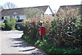
2
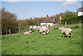
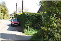
1066 Country Walk approaching Westfield
The long distance ascending towards the large village of Westfield - from the west.
Image: © Chris Heaton
Taken: 28 Apr 2013
0.04 miles
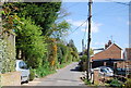
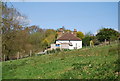
7
View to New Cut
Taken from Wheel Lane. The wood below is Horseman's Wood.
Image: © Simon Carey
Taken: 21 Feb 2007
0.07 miles
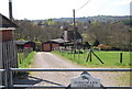
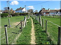
10
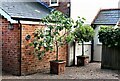
Potted fig and bay trees at Ivy Cottage, New Cut, Westfield
Image: © Patrick Roper
Taken: 29 Aug 2021
0.08 miles