IMAGES TAKEN NEAR TO
Jenners Lane, HASTINGS, TN35 4LH
Introduction
This page details the photographs taken nearby to Jenners Lane, TN35 4LH by members of the Geograph project.
The Geograph project started in 2005 with the aim of publishing, organising and preserving representative images for every square kilometre of Great Britain, Ireland and the Isle of Man.

There are currently over 7.5m images from over14,400 individuals and you can help contribute to the project by visiting https://www.geograph.org.uk
Image Map
Images are licensed for reuse under creativecommons.org/licenses/by-sa/2.0
Notes
- Clicking on the map will re-center to the selected point.
- The higher the marker number, the further away the image location is from the centre of the postcode.
Image Listing (5 Images Found)
Images are licensed for reuse under creativecommons.org/licenses/by-sa/2.0
Image
Details
Distance
1
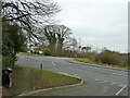
A259 road junctions, Bachelor's Bump
Looking from Martineau Lane across the A259 to Winchelsea Lane.
Image: © Robin Webster
Taken: 2 Mar 2013
0.15 miles
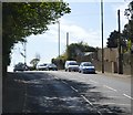
3
Barn conversion, Rye Road
Lidham Barn, formerly part of Lidham Farm, is dated 1831.
Image: © Robin Webster
Taken: 2 Mar 2013
0.18 miles
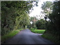
5
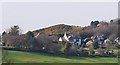
Batchelor's Bump (2)
A gorse crowned hill.
Image: © N Chadwick
Taken: 17 Apr 2010
0.24 miles