IMAGES TAKEN NEAR TO
Friars Crescent, HASTINGS, TN35 4ES
Introduction
This page details the photographs taken nearby to Friars Crescent, TN35 4ES by members of the Geograph project.
The Geograph project started in 2005 with the aim of publishing, organising and preserving representative images for every square kilometre of Great Britain, Ireland and the Isle of Man.

There are currently over 7.5m images from over14,400 individuals and you can help contribute to the project by visiting https://www.geograph.org.uk
Image Map
Images are licensed for reuse under creativecommons.org/licenses/by-sa/2.0
Notes
- Clicking on the map will re-center to the selected point.
- The higher the marker number, the further away the image location is from the centre of the postcode.
Image Listing (32 Images Found)
Images are licensed for reuse under creativecommons.org/licenses/by-sa/2.0
Image
Details
Distance
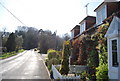
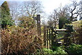
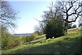
3
Friar's Bank, Friar's Hill
A private estate.
Image: © N Chadwick
Taken: 17 Apr 2010
0.05 miles
5
1066 Country Walk sign, Pett Rd, Friar's Hill
Image: © N Chadwick
Taken: 17 Apr 2010
0.05 miles
6
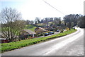
Houses on Friar's Bank, Friar's Hill
A small private estate, in the Sussex countryside.
Image: © N Chadwick
Taken: 17 Apr 2010
0.05 miles
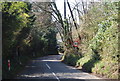
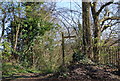
7
1066 Country Walk leaves Pett Rd, Friar's Hill
Image: © N Chadwick
Taken: 17 Apr 2010
0.05 miles
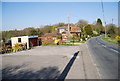
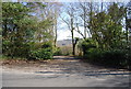
8
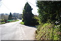
Junction of Pett Rd and Chapel Lane, Friar's Hill
Image: © N Chadwick
Taken: 17 Apr 2010
0.05 miles
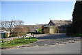
10
Entrance to a telephone exchange, Pett Rd
Image: © N Chadwick
Taken: 17 Apr 2010
0.10 miles