IMAGES TAKEN NEAR TO
Friars Hill Terrace, Friars Hill, HASTINGS, TN35 4ER
Introduction
This page details the photographs taken nearby to Friars Hill Terrace, Friars Hill, TN35 4ER by members of the Geograph project.
The Geograph project started in 2005 with the aim of publishing, organising and preserving representative images for every square kilometre of Great Britain, Ireland and the Isle of Man.

There are currently over 7.5m images from over14,400 individuals and you can help contribute to the project by visiting https://www.geograph.org.uk
Image Map (Loading...)


Getting Data...Please wait
Leaflet Map data © OpenStreetMap
Images are licensed for reuse under creativecommons.org/licenses/by-sa/2.0
Notes
- Clicking on the map will re-center to the selected point.
- The higher the marker number, the further away the image location is from the centre of the postcode.
Image Listing (19 Images Found)
Images are licensed for reuse under creativecommons.org/licenses/by-sa/2.0
Image
Details
Distance
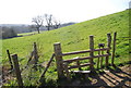
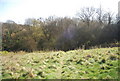
4
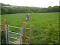
Footpath (part of the '1066 Country Walk') near Friar's Hill
Image: © Colin Park
Taken: 8 May 2011
0.11 miles
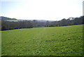
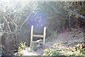
5
Stile on the 1066 Country Walk near Alder Shaw
Image: © N Chadwick
Taken: 17 Apr 2010
0.12 miles
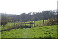
6
Stile entering a woodland on the 1066 Country Walk
Image: © N Chadwick
Taken: 17 Apr 2010
0.15 miles
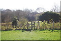
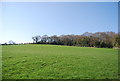
8
1066 Country Walk: south to Fairlight Hall
Image: © N Chadwick
Taken: 17 Apr 2010
0.17 miles
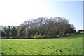
9
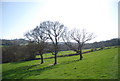
Three trees by the footpath near Alder Shaw
Image: © N Chadwick
Taken: 17 Apr 2010
0.18 miles