IMAGES TAKEN NEAR TO
Chick Hill, HASTINGS, TN35 4EQ
Introduction
This page details the photographs taken nearby to Chick Hill, TN35 4EQ by members of the Geograph project.
The Geograph project started in 2005 with the aim of publishing, organising and preserving representative images for every square kilometre of Great Britain, Ireland and the Isle of Man.

There are currently over 7.5m images from over14,400 individuals and you can help contribute to the project by visiting https://www.geograph.org.uk
Image Map
Images are licensed for reuse under creativecommons.org/licenses/by-sa/2.0
Notes
- Clicking on the map will re-center to the selected point.
- The higher the marker number, the further away the image location is from the centre of the postcode.
Image Listing (66 Images Found)
Images are licensed for reuse under creativecommons.org/licenses/by-sa/2.0
Image
Details
Distance
1
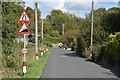
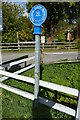
Chick Hill - Steep Hill 1:4
Chick Hill, Pett. 1:4 steep hill down sign.
Image: © Adam Morse
Taken: 30 Jul 2009
0.06 miles
3
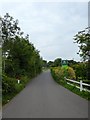
Pett Level
Seen from the path that leads down from the Royal Oak to Cliff End.
Image: © David M Clark
Taken: 20 May 2020
0.11 miles
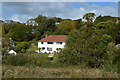
4
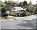
Chick Hill, Pett Level
The last building on the right hand side of the road just before the start of the hill is known as 1, Shady Nook. Planning permission has been approved, with conditions, by Rother District Council under application number RR/2011/23/P for "proposed remodelling and first floor partial extension with new driveway access".
This is Image after it had been remodelled.
Image: © John Baker
Taken: 13 Nov 2011
0.11 miles
5
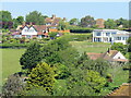
1 Shady Nook, Chick Hill
This house in Image can be seen in the distance, before it was remodelled.
Image: © John Baker
Taken: 28 Oct 2018
0.12 miles
6
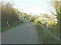
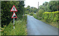
Pett Road, Cliff End
Looking north from the junction with Pett Level Road. The lane heads to the village of Pett and eventually the A259 near Batchelors Bump.
Image: © Simon Carey
Taken: 4 Aug 2019
0.12 miles
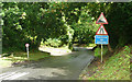
9
Chick Hill - Steep Hill 25%
Chick Hill, Pett. 25% steep hill up sign.
Image: © Adam Morse
Taken: 30 Jul 2009
0.15 miles