IMAGES TAKEN NEAR TO
Pett Level Road, HASTINGS, TN35 4EH
Introduction
This page details the photographs taken nearby to Pett Level Road, TN35 4EH by members of the Geograph project.
The Geograph project started in 2005 with the aim of publishing, organising and preserving representative images for every square kilometre of Great Britain, Ireland and the Isle of Man.

There are currently over 7.5m images from over14,400 individuals and you can help contribute to the project by visiting https://www.geograph.org.uk
Image Map
Images are licensed for reuse under creativecommons.org/licenses/by-sa/2.0
Notes
- Clicking on the map will re-center to the selected point.
- The higher the marker number, the further away the image location is from the centre of the postcode.
Image Listing (436 Images Found)
Images are licensed for reuse under creativecommons.org/licenses/by-sa/2.0
Image
Details
Distance
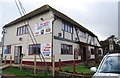
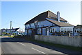
1
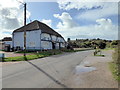
The Smuggler Inn, Pett Level
The pub is now closed
Image: © PAUL FARMER
Taken: 30 Sep 2017
0.00 miles
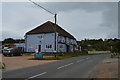
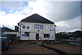
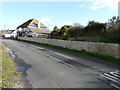
3
The Smuggler, Cliff End
Pub on Pett Level Road.
Image: © Oast House Archive
Taken: 2 Apr 2011
0.01 miles
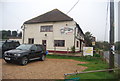
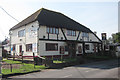
8
Pett - 2016
Pett, East Sussex, Pett Level, Pett Level Road, The Smuggler Freehouse
Image: © Helmut Zozmann
Taken: 21 Aug 2016
0.01 miles
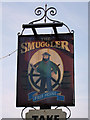
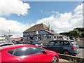
10
The Smugglers, Pett Level Road
This was Image when it was a thriving concern.
Image: © John Baker
Taken: 28 Oct 2018
0.01 miles