IMAGES TAKEN NEAR TO
Smugglers Way, HASTINGS, TN35 4DH
Introduction
This page details the photographs taken nearby to Smugglers Way, TN35 4DH by members of the Geograph project.
The Geograph project started in 2005 with the aim of publishing, organising and preserving representative images for every square kilometre of Great Britain, Ireland and the Isle of Man.

There are currently over 7.5m images from over14,400 individuals and you can help contribute to the project by visiting https://www.geograph.org.uk
Image Map (Loading...)


Getting Data...Please wait
Leaflet Map data © OpenStreetMap
Images are licensed for reuse under creativecommons.org/licenses/by-sa/2.0
Notes
- Clicking on the map will re-center to the selected point.
- The higher the marker number, the further away the image location is from the centre of the postcode.
Image Listing (58 Images Found)
Images are licensed for reuse under creativecommons.org/licenses/by-sa/2.0
Image
Details
Distance
1
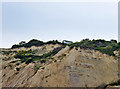
House on cliff edge, Fairlight Cove
An unstable cliff, above a very large slip. It appears from maps and aerial views that the lightly built bungalow was later moved or rebuilt further back from the edge.
Image: © Robin Webster
Taken: 5 Jul 2012
0.04 miles
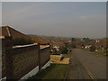
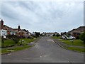
2
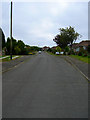
Smugglers Way
More bungalows on a road commemorating the favourite occupation of local residents in the 18th century.
Image: © Simon Carey
Taken: 5 May 2007
0.04 miles
3
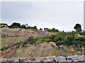
Cliff slip, Fairlight Cove
A lot of properties had their plots reduced considerably in usable size and in some cases had to abandon the houses. The summer house or similar seen here seems a going concern, but to the right a deck seems in a bad way and abandoned.
Image: © Robin Webster
Taken: 5 Jul 2012
0.05 miles
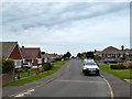
4
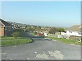
Smugglers Way, Fairlight
Taken from its junction with Bramble Way on an exceptionally warm Remembrance Sunday.
Image: © John Baker
Taken: 13 Nov 2011
0.05 miles
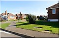
8
Bramble Way, Fairlight Cove
A residential road linking Shepherds Way to Smugglers Way built in the 1970s.
Image: © Simon Carey
Taken: 4 Aug 2019
0.06 miles
9
Heather Way, Fairlight Cove
A cul de sac off Bramble Way built in the 1970s.
Image: © Simon Carey
Taken: 4 Aug 2019
0.06 miles
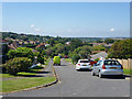
10
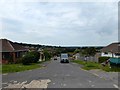
Smugglers Way, Fairlight Cove
Residential road that now heads north from the junction with Rockmead Road and Bramble Way. Originally it ran to the cliff top and a junction with Channel Way but that has been lost to cliff erosion.
Image: © Simon Carey
Taken: 4 Aug 2019
0.07 miles