IMAGES TAKEN NEAR TO
Shepherds Way, HASTINGS, TN35 4BD
Introduction
This page details the photographs taken nearby to Shepherds Way, TN35 4BD by members of the Geograph project.
The Geograph project started in 2005 with the aim of publishing, organising and preserving representative images for every square kilometre of Great Britain, Ireland and the Isle of Man.

There are currently over 7.5m images from over14,400 individuals and you can help contribute to the project by visiting https://www.geograph.org.uk
Image Map
Images are licensed for reuse under creativecommons.org/licenses/by-sa/2.0
Notes
- Clicking on the map will re-center to the selected point.
- The higher the marker number, the further away the image location is from the centre of the postcode.
Image Listing (50 Images Found)
Images are licensed for reuse under creativecommons.org/licenses/by-sa/2.0
Image
Details
Distance
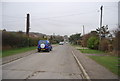
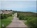
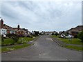
2
Junction of Shepherd's and Channel Ways-Saxon Shore Way
Image: © PAUL FARMER
Taken: 9 Jul 2012
0.05 miles
5
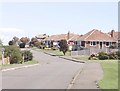
Bramble Way, Fairlight Cove
Fairlight Cove is an area of mainly post-War bungalow development.
Image: © David Kemp
Taken: 15 Aug 2008
0.06 miles
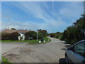
6
Channel Way
Gravel track and Saxon Shore Way at the top of the cliff.
Image: © Oast House Archive
Taken: 26 Jun 2012
0.09 miles
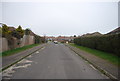
7
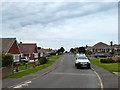
Bramble Way, Fairlight Cove
A residential road linking Shepherds Way to Smugglers Way built in the 1970s.
Image: © Simon Carey
Taken: 4 Aug 2019
0.09 miles
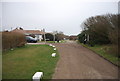
9

Modern house on Channel Way
Recently built house by the Saxon Shore Way.
Image: © Oast House Archive
Taken: 26 Jun 2012
0.09 miles
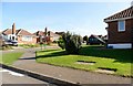
10
Heather Way, Fairlight Cove
A cul de sac off Bramble Way built in the 1970s.
Image: © Simon Carey
Taken: 4 Aug 2019
0.09 miles