IMAGES TAKEN NEAR TO
Firtree Road, HASTINGS, TN34 3TR
Introduction
This page details the photographs taken nearby to Firtree Road, TN34 3TR by members of the Geograph project.
The Geograph project started in 2005 with the aim of publishing, organising and preserving representative images for every square kilometre of Great Britain, Ireland and the Isle of Man.

There are currently over 7.5m images from over14,400 individuals and you can help contribute to the project by visiting https://www.geograph.org.uk
Image Map
Images are licensed for reuse under creativecommons.org/licenses/by-sa/2.0
Notes
- Clicking on the map will re-center to the selected point.
- The higher the marker number, the further away the image location is from the centre of the postcode.
Image Listing (100 Images Found)
Images are licensed for reuse under creativecommons.org/licenses/by-sa/2.0
Image
Details
Distance
5
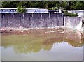
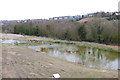
Derelict storage tank, former Broomgrove Power Station
Image: © Patrick Roper
Taken: 14 Apr 2002
0.11 miles
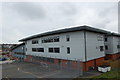
6
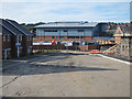
New housing estate under construction
A large residential development under construction on a parcel of land up to Ore railway station, accessed off Hughenden Road. The large grey building is part of Sussex Coast College Hastings.
Image: © Oast House Archive
Taken: 7 Aug 2011
0.11 miles
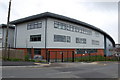
7
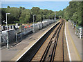
Ore railway station
A platforms only station access from a footpath from Hughenden Road.
Image: © Oast House Archive
Taken: 7 Aug 2011
0.12 miles