IMAGES TAKEN NEAR TO
Malvern Way, HASTINGS, TN34 3PX
Introduction
This page details the photographs taken nearby to Malvern Way, TN34 3PX by members of the Geograph project.
The Geograph project started in 2005 with the aim of publishing, organising and preserving representative images for every square kilometre of Great Britain, Ireland and the Isle of Man.

There are currently over 7.5m images from over14,400 individuals and you can help contribute to the project by visiting https://www.geograph.org.uk
Image Map
Images are licensed for reuse under creativecommons.org/licenses/by-sa/2.0
Notes
- Clicking on the map will re-center to the selected point.
- The higher the marker number, the further away the image location is from the centre of the postcode.
Image Listing (45 Images Found)
Images are licensed for reuse under creativecommons.org/licenses/by-sa/2.0
Image
Details
Distance
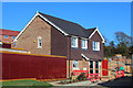
1
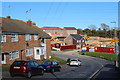
Pennine Rise & High Breezes development
Image: © Oast House Archive
Taken: 5 Apr 2015
0.01 miles
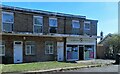
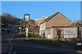
2
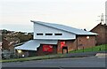
Broomgrove Community Centre, Hastings
At the corner of Malvern Way and Chiltern Drive.
Image: © Patrick Roper
Taken: 4 Nov 2021
0.01 miles
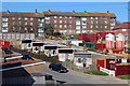
3
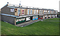
Shops & Apartments at Malvern Way
Image: © Oast House Archive
Taken: 5 Apr 2015
0.01 miles
4
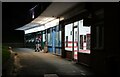
Row of shops at night in Broomgrove, Hastings
These shops are part of a very short row in Malvern Way. They are, from left to right, a Costcutter, a laundrette and Hastings Fried Chicken.
Image: © Patrick Roper
Taken: 4 Nov 2021
0.02 miles
5
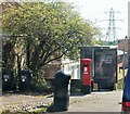
Red letter box and other suburban feattures, Malvern Way, Hastings
Image: © Patrick Roper
Taken: 12 Sep 2022
0.02 miles
6
Welcome Pharmacy and houses in Malvern Way, Hastings
Image: © Patrick Roper
Taken: 12 Sep 2022
0.03 miles

10
The Malvern
Closed pub on Malvern Way.
Image: © Oast House Archive
Taken: 29 Feb 2012
0.05 miles