IMAGES TAKEN NEAR TO
Robertsons Hill, HASTINGS, TN34 3NU
Introduction
This page details the photographs taken nearby to Robertsons Hill, TN34 3NU by members of the Geograph project.
The Geograph project started in 2005 with the aim of publishing, organising and preserving representative images for every square kilometre of Great Britain, Ireland and the Isle of Man.

There are currently over 7.5m images from over14,400 individuals and you can help contribute to the project by visiting https://www.geograph.org.uk
Image Map
Images are licensed for reuse under creativecommons.org/licenses/by-sa/2.0
Notes
- Clicking on the map will re-center to the selected point.
- The higher the marker number, the further away the image location is from the centre of the postcode.
Image Listing (71 Images Found)
Images are licensed for reuse under creativecommons.org/licenses/by-sa/2.0
Image
Details
Distance
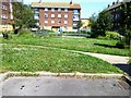
1
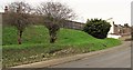
Landscaped bank in Robertsons Hill, Halton, Hastings
The small trees are hawthorns and the bush Japanese spindle (Euonymus japonicus).
Image: © Patrick Roper
Taken: 29 Jan 2007
0.02 miles
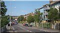
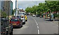
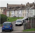
3
Hardwicke Road looking south west, Halton in Hastings
Image: © Patrick Roper
Taken: 29 Jan 2007
0.04 miles
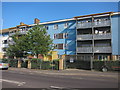
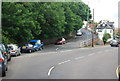
4
Halton Crescent in the Halton area of Hastings
Image: © Patrick Roper
Taken: 29 Jan 2007
0.05 miles
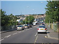
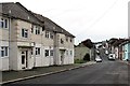
5
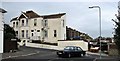
House at top of Robertsons Hill, Halton in Hastings
The photograph was taken from the north-eastern end of Hardwicke Road.
Image: © Patrick Roper
Taken: 29 Jan 2007
0.05 miles