IMAGES TAKEN NEAR TO
St. Marys Road, HASTINGS, TN34 3LW
Introduction
This page details the photographs taken nearby to St. Marys Road, TN34 3LW by members of the Geograph project.
The Geograph project started in 2005 with the aim of publishing, organising and preserving representative images for every square kilometre of Great Britain, Ireland and the Isle of Man.

There are currently over 7.5m images from over14,400 individuals and you can help contribute to the project by visiting https://www.geograph.org.uk
Image Map
Images are licensed for reuse under creativecommons.org/licenses/by-sa/2.0
Notes
- Clicking on the map will re-center to the selected point.
- The higher the marker number, the further away the image location is from the centre of the postcode.
Image Listing (217 Images Found)
Images are licensed for reuse under creativecommons.org/licenses/by-sa/2.0
Image
Details
Distance
2
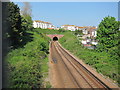
Hastings line tunnel
Looking towards the tunnel between Hastings and Ore stations from Image
Image: © Oast House Archive
Taken: 23 Apr 2011
0.02 miles
7
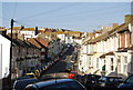
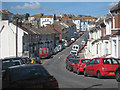
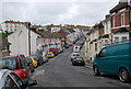
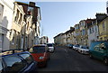
St Mary's Rd (3)
A road of Victorian houses.
Image: © N Chadwick
Taken: 17 Apr 2010
0.05 miles
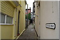
8
Braycastle Walk
A cut through between Manor Rd and St Mary's Rd.
Image: © N Chadwick
Taken: 17 Apr 2010
0.05 miles
9
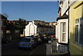
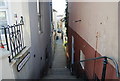
Braycastle Walk, St Mary's Rd
An urban footpath
Image: © N Chadwick
Taken: 10 Jun 2009
0.05 miles
10
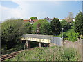
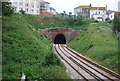
Footbridge over the Hastings Line
This footbridge connects Milward Road to St James's Road and Quarry Road on the other side. Shortly past the bridge the railway goes into a tunnel.
Image: © Oast House Archive
Taken: 23 Apr 2011
0.05 miles