IMAGES TAKEN NEAR TO
Whitefriars Road, HASTINGS, TN34 3LA
Introduction
This page details the photographs taken nearby to Whitefriars Road, TN34 3LA by members of the Geograph project.
The Geograph project started in 2005 with the aim of publishing, organising and preserving representative images for every square kilometre of Great Britain, Ireland and the Isle of Man.

There are currently over 7.5m images from over14,400 individuals and you can help contribute to the project by visiting https://www.geograph.org.uk
Image Map
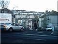
Images are licensed for reuse under creativecommons.org/licenses/by-sa/2.0
Notes
- Clicking on the map will re-center to the selected point.
- The higher the marker number, the further away the image location is from the centre of the postcode.
Image Listing (225 Images Found)
Images are licensed for reuse under creativecommons.org/licenses/by-sa/2.0
Image
Details
Distance
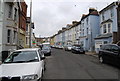
1
St George's Rd
A street of Victorian houses.
Image: © N Chadwick
Taken: 17 Apr 2010
0.01 miles
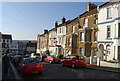
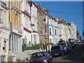
2
Emmanuel Rd
A road of Victorian terraced villas.
Image: © N Chadwick
Taken: 17 Apr 2010
0.01 miles
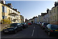
3
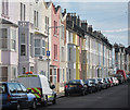
Whitefriars Road
Terraced residential road.
Image: © Oast House Archive
Taken: 13 Sep 2011
0.01 miles
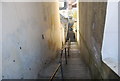
6
Cut through between Vicarage Rd and Manor Rd
Image: © N Chadwick
Taken: 17 Apr 2010
0.05 miles
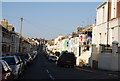
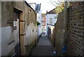
7
Manor Road
This was taken from Mount Pleasant Road. It shows the view looking down Manor Road and across to the West Hill.
Image: © Terry Head
Taken: 9 Jan 2009
0.05 miles
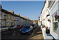
8
Manor Road
Colourful residential terraced one way road.
Image: © Oast House Archive
Taken: 7 Aug 2011
0.06 miles