IMAGES TAKEN NEAR TO
Roebuck Street, HASTINGS, TN34 3BB
Introduction
This page details the photographs taken nearby to Roebuck Street, TN34 3BB by members of the Geograph project.
The Geograph project started in 2005 with the aim of publishing, organising and preserving representative images for every square kilometre of Great Britain, Ireland and the Isle of Man.

There are currently over 7.5m images from over14,400 individuals and you can help contribute to the project by visiting https://www.geograph.org.uk
Image Map
Images are licensed for reuse under creativecommons.org/licenses/by-sa/2.0
Notes
- Clicking on the map will re-center to the selected point.
- The higher the marker number, the further away the image location is from the centre of the postcode.
Image Listing (3427 Images Found)
Images are licensed for reuse under creativecommons.org/licenses/by-sa/2.0
Image
Details
Distance
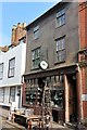
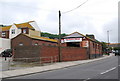
1
CAT Components
On Roebuck Street.
Image: © Oast House Archive
Taken: 23 Oct 2010
0.00 miles
2
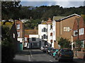
Roebuck Street
Short road between The Bourne and High Street.
Image: © Oast House Archive
Taken: 23 Oct 2010
0.00 miles

5
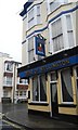
Duke of Wellington
One of three pubs left on the High St.
Image: © N Chadwick
Taken: 25 Mar 2010
0.01 miles
6
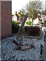
An old anchor
The barnacle-encrusted anchor is by the side of The Bourne in Hastings. There is no plaque to say which ship it came from.
Image: © Stephen Craven
Taken: 12 Aug 2012
0.01 miles
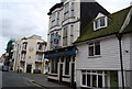
9
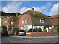
Houses on Roebuck Street
Semi detached houses with half hipped gambrel roof. At junction with the Bourne.
Image: © Oast House Archive
Taken: 23 Oct 2010
0.02 miles