IMAGES TAKEN NEAR TO
De Chardin Drive, HASTINGS, TN34 2UD
Introduction
This page details the photographs taken nearby to De Chardin Drive, TN34 2UD by members of the Geograph project.
The Geograph project started in 2005 with the aim of publishing, organising and preserving representative images for every square kilometre of Great Britain, Ireland and the Isle of Man.

There are currently over 7.5m images from over14,400 individuals and you can help contribute to the project by visiting https://www.geograph.org.uk
Image Map
Images are licensed for reuse under creativecommons.org/licenses/by-sa/2.0
Notes
- Clicking on the map will re-center to the selected point.
- The higher the marker number, the further away the image location is from the centre of the postcode.
Image Listing (85 Images Found)
Images are licensed for reuse under creativecommons.org/licenses/by-sa/2.0
Image
Details
Distance
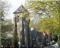
1
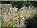
Headstones at old St Helen's Church
Image: © Oast House Archive
Taken: 24 Aug 2019
0.08 miles
2
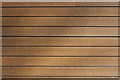
Fibre cement cladding detail, Ridgelands
Image: © Oast House Archive
Taken: 5 Apr 2015
0.08 miles
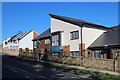
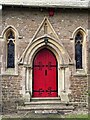
4
Elphinstone Road, St. Helens, Hastings
Image: © nick macneill
Taken: 24 Feb 2012
0.08 miles
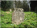
5
Headstone at old St Helen's Church
Image: © Oast House Archive
Taken: 24 Aug 2019
0.09 miles
6

Fibre cement cladding, Elphinstone Road
Image: © Oast House Archive
Taken: 26 Mar 2015
0.09 miles
9
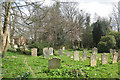
Graveyard of Old Church of St Helen
Image: © Oast House Archive
Taken: 11 Apr 2010
0.09 miles
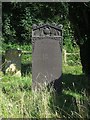
10
Headstone at Old Church of St Helen
A decorative headstone from 1779.
Image: © Oast House Archive
Taken: 11 Apr 2010
0.09 miles