IMAGES TAKEN NEAR TO
Sheerwater Crescent, HASTINGS, TN34 2NZ
Introduction
This page details the photographs taken nearby to Sheerwater Crescent, TN34 2NZ by members of the Geograph project.
The Geograph project started in 2005 with the aim of publishing, organising and preserving representative images for every square kilometre of Great Britain, Ireland and the Isle of Man.

There are currently over 7.5m images from over14,400 individuals and you can help contribute to the project by visiting https://www.geograph.org.uk
Image Map
Images are licensed for reuse under creativecommons.org/licenses/by-sa/2.0
Notes
- Clicking on the map will re-center to the selected point.
- The higher the marker number, the further away the image location is from the centre of the postcode.
Image Listing (18 Images Found)
Images are licensed for reuse under creativecommons.org/licenses/by-sa/2.0
Image
Details
Distance
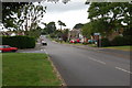
1
Sheerwater Crescent North bus stop
The southbound stop on Parkstone Road.
Image: © Robin Webster
Taken: 31 Jan 2013
0.09 miles
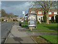
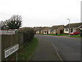
2
Houses on Hillside Road
Opposite the end of Parkstone Road.
Image: © Robin Webster
Taken: 31 Jan 2013
0.14 miles
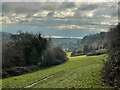
4
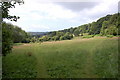
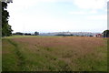
Field near St Helens woods
Looking towards Hastings. Note the lying down horse!
Image: © Julian P Guffogg
Taken: 29 Jun 2008
0.16 miles
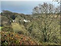
8
William Parker school playing fields
With Hastings and the sea in distance.
Image: © Julian P Guffogg
Taken: 29 Jun 2008
0.20 miles
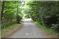
9
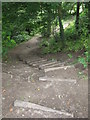
Steps in St Helen's Wood
These steps lead from St Helen's Wood Road into the northern part of St Helen's Park (known locally as St Helen's Wood).
Image: © don cload
Taken: 13 Jun 2009
0.21 miles