IMAGES TAKEN NEAR TO
Park View, HASTINGS, TN34 2HB
Introduction
This page details the photographs taken nearby to Park View, TN34 2HB by members of the Geograph project.
The Geograph project started in 2005 with the aim of publishing, organising and preserving representative images for every square kilometre of Great Britain, Ireland and the Isle of Man.

There are currently over 7.5m images from over14,400 individuals and you can help contribute to the project by visiting https://www.geograph.org.uk
Image Map (Loading...)


Getting Data...Please wait
Leaflet Map data © OpenStreetMap
Images are licensed for reuse under creativecommons.org/licenses/by-sa/2.0
Notes
- Clicking on the map will re-center to the selected point.
- The higher the marker number, the further away the image location is from the centre of the postcode.
Image Listing (78 Images Found)
Images are licensed for reuse under creativecommons.org/licenses/by-sa/2.0
Image
Details
Distance
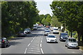
1

Park Crescent, junction with Park View, Hastings
Image: © Stacey Harris
Taken: 30 Jun 2012
0.04 miles

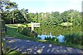
3
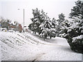
Snowy path through Alexandra Park
Beside St Helen's Road to the left.
Image: © Oast House Archive
Taken: 2 Dec 2010
0.09 miles

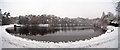
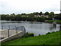
9
Frozen Buckshole reservoir, St Leonards
Image: © Julian P Guffogg
Taken: 4 Feb 2012
0.11 miles
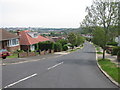
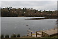
10
Hastings-Buckshole Reservoir
In Alexandra Park.
Image: © Ian Rob
Taken: 29 Jul 2020
0.12 miles