IMAGES TAKEN NEAR TO
Norcross Close, HASTINGS, TN34 2FB
Introduction
This page details the photographs taken nearby to Norcross Close, TN34 2FB by members of the Geograph project.
The Geograph project started in 2005 with the aim of publishing, organising and preserving representative images for every square kilometre of Great Britain, Ireland and the Isle of Man.

There are currently over 7.5m images from over14,400 individuals and you can help contribute to the project by visiting https://www.geograph.org.uk
Image Map
Images are licensed for reuse under creativecommons.org/licenses/by-sa/2.0
Notes
- Clicking on the map will re-center to the selected point.
- The higher the marker number, the further away the image location is from the centre of the postcode.
Image Listing (43 Images Found)
Images are licensed for reuse under creativecommons.org/licenses/by-sa/2.0
Image
Details
Distance
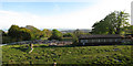
4
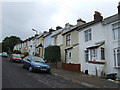
Pilot Road, Hastings
It is as steep as it looks!
Image: © Jonathan Billinger
Taken: 7 Jun 2007
0.14 miles
5
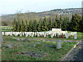
War graves, Hastings Cemetery
They are quite a way from the regular war memorial in the cemetery.
Image: © Robin Webster
Taken: 31 Jan 2013
0.14 miles
6
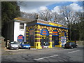
Hastings Tyres & Wheels
On The Ridge, this colourful shop sells car alloy wheels and tyres, and other car related items.
Image: © Oast House Archive
Taken: 11 Apr 2010
0.15 miles
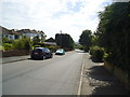
9
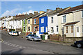
Terraced houses, Pilot Road
A row of 21 houses stepping up the hill.
Image: © Robin Webster
Taken: 31 Jan 2013
0.17 miles