IMAGES TAKEN NEAR TO
Brookland Close, HASTINGS, TN34 2DF
Introduction
This page details the photographs taken nearby to Brookland Close, TN34 2DF by members of the Geograph project.
The Geograph project started in 2005 with the aim of publishing, organising and preserving representative images for every square kilometre of Great Britain, Ireland and the Isle of Man.

There are currently over 7.5m images from over14,400 individuals and you can help contribute to the project by visiting https://www.geograph.org.uk
Image Map (Loading...)


Getting Data...Please wait
Leaflet Map data © OpenStreetMap
Images are licensed for reuse under creativecommons.org/licenses/by-sa/2.0
Notes
- Clicking on the map will re-center to the selected point.
- The higher the marker number, the further away the image location is from the centre of the postcode.
Image Listing (57 Images Found)
Images are licensed for reuse under creativecommons.org/licenses/by-sa/2.0
Image
Details
Distance
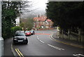
1
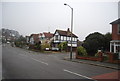
Elphinstone Rd, Elphinstone Avenue junction
Image: © N Chadwick
Taken: 25 Mar 2010
0.11 miles
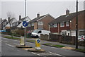
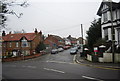
7
Hughenden Rd
Part of a one-way system in the suburbs of Hastings.
Image: © N Chadwick
Taken: 25 Mar 2010
0.16 miles
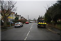
8
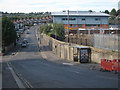
New housing estate under construction
To the right a large residential development under construction on a parcel of land up to Ore railway station, accessed off Hughenden Road. The large grey building is part of Sussex Coast College Hastings.
Image: © Oast House Archive
Taken: 7 Aug 2011
0.16 miles
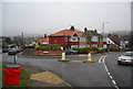
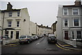
10

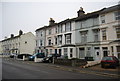
Crescent off Mount Pleasant Road, Hastings
Image: © Oast House Archive
Taken: 31 May 2009
0.16 miles