IMAGES TAKEN NEAR TO
Mann Street, HASTINGS, TN34 1SE
Introduction
This page details the photographs taken nearby to Mann Street, TN34 1SE by members of the Geograph project.
The Geograph project started in 2005 with the aim of publishing, organising and preserving representative images for every square kilometre of Great Britain, Ireland and the Isle of Man.

There are currently over 7.5m images from over14,400 individuals and you can help contribute to the project by visiting https://www.geograph.org.uk
Image Map (Loading...)


Getting Data...Please wait
Leaflet Map data © OpenStreetMap
Images are licensed for reuse under creativecommons.org/licenses/by-sa/2.0
Notes
- Clicking on the map will re-center to the selected point.
- The higher the marker number, the further away the image location is from the centre of the postcode.
Image Listing (1012 Images Found)
Images are licensed for reuse under creativecommons.org/licenses/by-sa/2.0
Image
Details
Distance
1
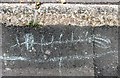
Animal chalked on pavement, Mann Street, Hastings
The purpose of this herringbone creature chalked on the tarmac of the pavement is not at all clear. Presumably done by children but with a curious rock art feel about it.
Image: © Patrick Roper
Taken: 21 Aug 2012
0.01 miles
2
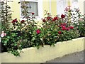
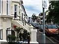
Roses in Mann Street, Hastings
These roses at no. 4 Mann Street are growing in a very narrow strip in front of the house, almost a windowbox. Mann Street is possibly named after the Mann family who were professional photographers and artists in this part of Hastings and recorded much of the past of the town.
Image: © Patrick Roper
Taken: 21 Aug 2012
0.01 miles
3
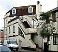
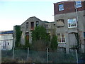
Building in Mann Street, Hastings
At the north eastern end of the street in Hastings town centre. Mann Street is possibly named after the Mann family who were professional photographers and artists in this part of Hastings and recorded much of the past of the town.
Image: © Patrick Roper
Taken: 21 Aug 2012
0.02 miles
4
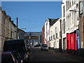
Earl Street
Terraced housing to left and warehouses to right.
Image: © Oast House Archive
Taken: 12 Sep 2010
0.03 miles
5
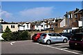
North eastern end of Cornwalliis Street Car Park, Hastings
The closer buildings in the background have frontages in Waldegrave Street and St. Andrew's Square. The tower of the Emmanuel Church on West Hill can be seen on the horizon in the centre of the picture. Most of Cornwallis Street lies to the east of the car park beyond St. Andrew's Square and does not connect with the short piece of road in which the car park is situated.
Image: © Patrick Roper
Taken: 26 Jul 2021
0.03 miles
6
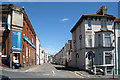
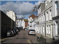
Mann Street, Hastings
Looking north east along Mann Street near Hastings town centre. Mann Street is possibly named after the Mann family who were professional photographers and artists in this part of Hastings and recorded much of the past of the town.
Image: © Patrick Roper
Taken: 21 Aug 2012
0.03 miles
7

Fish bar signs overlooking the Cornwallis Street car park, Hastings
Image: © Patrick Roper
Taken: 26 Jul 2021
0.04 miles
9
Buildings near Hastings Station
These buildings are to the south of the railway line on the approach to Hastings Station.
Image: © Christine Matthews
Taken: 22 Dec 2009
0.04 miles