IMAGES TAKEN NEAR TO
Portland Villas, Portland Steps, HASTINGS, TN34 1PX
Introduction
This page details the photographs taken nearby to Portland Villas, Portland Steps, TN34 1PX by members of the Geograph project.
The Geograph project started in 2005 with the aim of publishing, organising and preserving representative images for every square kilometre of Great Britain, Ireland and the Isle of Man.

There are currently over 7.5m images from over14,400 individuals and you can help contribute to the project by visiting https://www.geograph.org.uk
Image Map
Images are licensed for reuse under creativecommons.org/licenses/by-sa/2.0
Notes
- Clicking on the map will re-center to the selected point.
- The higher the marker number, the further away the image location is from the centre of the postcode.
Image Listing (1641 Images Found)
Images are licensed for reuse under creativecommons.org/licenses/by-sa/2.0
Image
Details
Distance
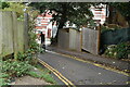
2
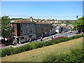
Castle Hill Road
Castle Hill Road continues left and turns into Wellington Road to the right.
Image: © Oast House Archive
Taken: 26 Jun 2010
0.02 miles
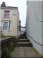
3
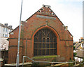
Chapel on Alley Way
Snug between houses on Portland Place and Castle Hill Road.
Image: © Oast House Archive
Taken: 26 Jun 2010
0.02 miles
5
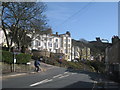
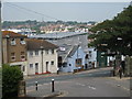
Cyclist on Castle Hill Road
Castle Hill Road is to the left to West Hill and straight on to town centre. Viewed from Milward Road.
Image: © Oast House Archive
Taken: 2 Apr 2010
0.02 miles
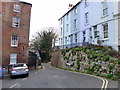
9
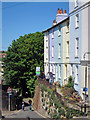
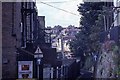
Castle Hill Passage
A one way street down to Queen's Road. A colourful terrace of houses at the junction Castle Hill Road.
Image: © Oast House Archive
Taken: 2 May 2011
0.03 miles
10
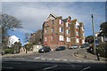
Houses on Castle Hill Road
Four storey houses at the bottom near the road junction. The road continues up to the West Hill recreation ground.
Image: © Oast House Archive
Taken: 2 Apr 2010
0.03 miles