IMAGES TAKEN NEAR TO
Coombe Hill, BATTLE, TN33 9NH
Introduction
This page details the photographs taken nearby to Coombe Hill, TN33 9NH by members of the Geograph project.
The Geograph project started in 2005 with the aim of publishing, organising and preserving representative images for every square kilometre of Great Britain, Ireland and the Isle of Man.

There are currently over 7.5m images from over14,400 individuals and you can help contribute to the project by visiting https://www.geograph.org.uk
Image Map
Images are licensed for reuse under creativecommons.org/licenses/by-sa/2.0
Notes
- Clicking on the map will re-center to the selected point.
- The higher the marker number, the further away the image location is from the centre of the postcode.
Image Listing (8 Images Found)
Images are licensed for reuse under creativecommons.org/licenses/by-sa/2.0
Image
Details
Distance
1
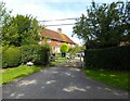
Combe Hill Cottage, Combe Hill
Dating back to the 18th century. Now one dwelling as originally listed as cottages.
Image: © Simon Carey
Taken: 3 Sep 2023
0.01 miles
2
Coombe Hill Cottage near Ninfield
Coombe Hill Cottage is to be found in Compass Lane, a small back road that runs between Standard Hill at Ninfield and the A271 south of Ashburnham Place. The charming brick and tile-clad cottage is Grade II listed.
Image: © Nigel Stickells
Taken: 1 Jan 2007
0.01 miles
3
Coomb Meadow
The name of the field according to Ninfield's 1844 tithe map bounded by Combe Hill to the east and Combe Wood to the west.
Image: © Simon Carey
Taken: 3 Sep 2023
0.07 miles
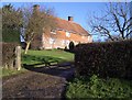
4
Combe Hill Farm, Combe Hill
The former farmhouse dates back to at least the 16th century. The farm's former outbuildings have now been converted into dwellings.
Image: © Simon Carey
Taken: 3 Sep 2023
0.11 miles
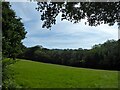
5
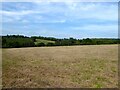
Kiln Field
The name of the field according to Ninfield's 1844 tithe map bounded by Combe Hill to the west and Ninfield Stream to the north. Compass Wood is in the distance to the left.
Image: © Simon Carey
Taken: 3 Sep 2023
0.12 miles
6
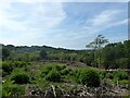
Combe Wood
Recent logging has allowed for the current view.
Image: © Simon Carey
Taken: 3 Sep 2023
0.17 miles
7
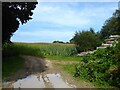
Sheepwash Field
The name of the field according to Ashburnham's 1839 tithe map located to the north of Compass Lane and east of Compass Wood.
Image: © Simon Carey
Taken: 3 Sep 2023
0.22 miles
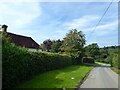
8
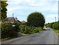
Marlpits Lane, Ninfield
Heading north out of the village before meandering its way to Catsfield.
Image: © Simon Carey
Taken: 3 Sep 2023
0.24 miles