IMAGES TAKEN NEAR TO
Kitchenham Road, BATTLE, TN33 9ND
Introduction
This page details the photographs taken nearby to Kitchenham Road, TN33 9ND by members of the Geograph project.
The Geograph project started in 2005 with the aim of publishing, organising and preserving representative images for every square kilometre of Great Britain, Ireland and the Isle of Man.

There are currently over 7.5m images from over14,400 individuals and you can help contribute to the project by visiting https://www.geograph.org.uk
Image Map (Loading...)


Getting Data...Please wait
Leaflet Map data © OpenStreetMap
Images are licensed for reuse under creativecommons.org/licenses/by-sa/2.0
Notes
- Clicking on the map will re-center to the selected point.
- The higher the marker number, the further away the image location is from the centre of the postcode.
Image Listing (8 Images Found)
Images are licensed for reuse under creativecommons.org/licenses/by-sa/2.0
Image
Details
Distance
1
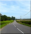
Kitchenham Road
The A271 looking east from the junction with Hammer Hill. The current road dates from around the 1830s replacing an older one a little to the north which skirted Hammer and Burrage Woods. Both this and the old route is marked on Ashburnham's 1839 tithe map.
Image: © Simon Carey
Taken: 3 Sep 2023
0.06 miles
2
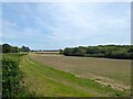
Hawthy Field
The name of the field according to Ashburnham's 1839 tithe map bounded by Kitchenham Road, the A271, to the north, and Luxford's Wood to the south.
Image: © Simon Carey
Taken: 3 Sep 2023
0.12 miles
3
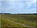
Lowes Pasture/Middle Lowes
The name of the fields according to Ashburnham's 1839 tithe map that have been merged. Lowes Pasture is in the foreground adjacent to the A271, whilst Middle Lowes is to to the south bounded by Compass Lane to the east and Luxford's wood to the west. Compass Cottages are visible on the left.
Image: © Simon Carey
Taken: 3 Sep 2023
0.17 miles
5
View by the A271
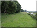
A swathe of pasture between the main road and the woods surrounding the Ashburnham estate.
Image: © Jonathan Billinger
Taken: 7 Jun 2007
0.20 miles
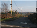
6
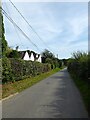
Compass Cottages, Compass Lane
Built in the late 19th century.
Image: © Simon Carey
Taken: 3 Sep 2023
0.20 miles
7
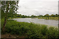
Broad Water, Ashburnham Place
The more westerly of the two larger lakes at Ashburnham Place.
Image: © Ian Capper
Taken: 20 Jun 2010
0.23 miles
8
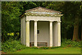
Mock temple
A mock temple in the grounds of Ashburnham Place, overlooking Broad Water.
Image: © Ian Capper
Taken: 20 Jun 2010
0.23 miles