IMAGES TAKEN NEAR TO
Frickley Lane, BATTLE, TN33 9LZ
Introduction
This page details the photographs taken nearby to Frickley Lane, TN33 9LZ by members of the Geograph project.
The Geograph project started in 2005 with the aim of publishing, organising and preserving representative images for every square kilometre of Great Britain, Ireland and the Isle of Man.

There are currently over 7.5m images from over14,400 individuals and you can help contribute to the project by visiting https://www.geograph.org.uk
Image Map
Images are licensed for reuse under creativecommons.org/licenses/by-sa/2.0
Notes
- Clicking on the map will re-center to the selected point.
- The higher the marker number, the further away the image location is from the centre of the postcode.
Image Listing (2 Images Found)
Images are licensed for reuse under creativecommons.org/licenses/by-sa/2.0
Image
Details
Distance
1
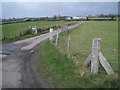
Entrance Road to Burnt Barns Farm
This entrance and farm road to Burnt Barns Farm is to be found on a back lane between Ninfield and the A271 to Battle.
Image: © Nigel Stickells
Taken: 28 Feb 2007
0.17 miles
2
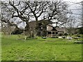
Converted barn by Freckley Hollow
Image: © Oast House Archive
Taken: 31 Mar 2021
0.24 miles