IMAGES TAKEN NEAR TO
Denbeigh Villas, BATTLE, TN33 9HZ
Introduction
This page details the photographs taken nearby to Denbeigh Villas, TN33 9HZ by members of the Geograph project.
The Geograph project started in 2005 with the aim of publishing, organising and preserving representative images for every square kilometre of Great Britain, Ireland and the Isle of Man.

There are currently over 7.5m images from over14,400 individuals and you can help contribute to the project by visiting https://www.geograph.org.uk
Image Map (Loading...)


Getting Data...Please wait
Leaflet Map data © OpenStreetMap
Images are licensed for reuse under creativecommons.org/licenses/by-sa/2.0
Notes
- Clicking on the map will re-center to the selected point.
- The higher the marker number, the further away the image location is from the centre of the postcode.
Image Listing (29 Images Found)
Images are licensed for reuse under creativecommons.org/licenses/by-sa/2.0
Image
Details
Distance
1
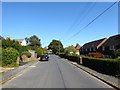
Denbigh Road, Hooe Common
With Denbigh Court on the right.
Image: © Simon Carey
Taken: 21 Sep 2019
0.01 miles
3
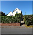
Old Post House, Denbigh Road, Hooe Common
Former village post office located between Denbigh Road and Top Road.
Image: © Simon Carey
Taken: 21 Sep 2019
0.03 miles
4
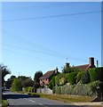
Top Road, Hooe Common
The B2095 passes through the settlement of Hooe Common and links the A259 on the Pevensey Levels to the village of Ninfield. Holly Cottage and the roof of Sunkyst Cottage are on the right.
Image: © Simon Carey
Taken: 21 Sep 2019
0.04 miles
5

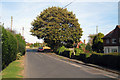
Red Lion inn sign, Hooe Common
These inn signs on grass islands are at both ends of the short road on the left connecting with the main B2095 road. The inn is the near left corner, rather set back.
Image: © Robin Webster
Taken: 11 Feb 2012
0.04 miles


8
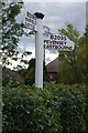
Old Direction Sign - Signpost by the B2095, Hooe Common
Black iron cap finial - 3 arms; East Sussex wood with number by the B2095, in parish of Hooe (Wealden District), in hedge at back of footpath (bordering private garden) at junction of unnamed road through village of Hooe Common with the B2095.
Surveyed
Milestone Society National ID: SX_TQ6910A
Image: © Milestone Society
Taken: Unknown
0.06 miles
9
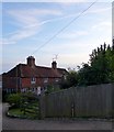
Elizabethan Cottages, Top Road, Hooe Common
The house dates from the late 16th century and may well have been built as the village workhouse which it remained until the Poor Law act of 1834. Now a pair of cottages.
Image: © Simon Carey
Taken: 21 Sep 2019
0.06 miles
10
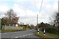
The B2095 at Hooe Common, East Sussex
Image: © nick macneill
Taken: 9 Nov 2011
0.07 miles