IMAGES TAKEN NEAR TO
Denbigh Road, BATTLE, TN33 9HP
Introduction
This page details the photographs taken nearby to Denbigh Road, TN33 9HP by members of the Geograph project.
The Geograph project started in 2005 with the aim of publishing, organising and preserving representative images for every square kilometre of Great Britain, Ireland and the Isle of Man.

There are currently over 7.5m images from over14,400 individuals and you can help contribute to the project by visiting https://www.geograph.org.uk
Image Map (Loading...)


Getting Data...Please wait
Leaflet Map data © OpenStreetMap
Images are licensed for reuse under creativecommons.org/licenses/by-sa/2.0
Notes
- Clicking on the map will re-center to the selected point.
- The higher the marker number, the further away the image location is from the centre of the postcode.
Image Listing (8 Images Found)
Images are licensed for reuse under creativecommons.org/licenses/by-sa/2.0
Image
Details
Distance
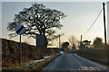
1
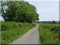
Jarmans Lane
This is looking along Jarmans Lane from the junction with the B2095. Jarmans Lane is a short and narrow little road linking the B2095 with Denbigh Road in the distance where the hedgerow is on far side of the right hand field.
Image: © Marathon
Taken: 5 Jun 2016
0.13 miles
2
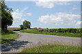
Junction of Jarman's Lane and B2095
Image: © Julian P Guffogg
Taken: 14 Jun 2009
0.17 miles
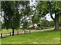
3
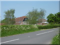
Bunts Barn
This is looking across the B2095 from the junction with Jarmans Lane.
Image: © Marathon
Taken: 5 Jun 2016
0.17 miles
5
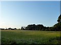
Old Hop Garden
The name of the field according to Hooe's 1839 tithe map located to the south of the current treatment works.
Image: © Simon Carey
Taken: 21 Sep 2019
0.21 miles
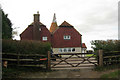
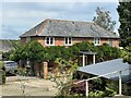
8
Oast House at New Wood Cottage, Top Road, Hooe
Image: © Oast House Archive
Taken: 9 Jul 2021
0.23 miles