IMAGES TAKEN NEAR TO
Hooe, BATTLE, TN33 9HD
Introduction
This page details the photographs taken nearby to TN33 9HD by members of the Geograph project.
The Geograph project started in 2005 with the aim of publishing, organising and preserving representative images for every square kilometre of Great Britain, Ireland and the Isle of Man.

There are currently over 7.5m images from over14,400 individuals and you can help contribute to the project by visiting https://www.geograph.org.uk
Image Map (Loading...)


Getting Data...Please wait
Leaflet Map data © OpenStreetMap
Images are licensed for reuse under creativecommons.org/licenses/by-sa/2.0
Notes
- Clicking on the map will re-center to the selected point.
- The higher the marker number, the further away the image location is from the centre of the postcode.
Image Listing (7 Images Found)
Images are licensed for reuse under creativecommons.org/licenses/by-sa/2.0
Image
Details
Distance
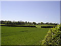
2
Nut Brown Farm
Looking up from the edge of the Pevensey Levels.
Image: © Robin Webster
Taken: 11 Feb 2012
0.18 miles
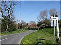
3
Bends on B2095
A green 2000 Rover Mini approaches a left hand bend and on towards Ninfield. From junction with Horsewalk (lane).
Image: © Oast House Archive
Taken: 26 Jun 2010
0.22 miles
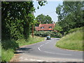
4
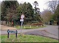
Glebe Cottage
Located at the junction of Top Road, the B2095, and Kiln Lane.
Image: © Simon Carey
Taken: 17 Apr 2010
0.23 miles
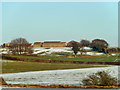
5
Kiln Lane, Hooe
This is the junction of Kiln Lane and Horsewalk (B2095). The gate to the right of the postbox leads to a footpath which runs across fields to Hooe Church.
Image: © Kevin Gordon
Taken: 22 Feb 2009
0.23 miles
6
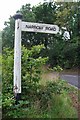
Old Direction Sign - Signpost by the B2095, Hooe
Black iron cap finial - 1 arm; East Sussex wood by the B2095, in parish of Hooe (Wealden District), verge opposite junction of 'Horse Walk' with B2095.
Refurbished and name changed from 'Narrow Road' to 'Horse Walk' after 2012.
Surveyed
Milestone Society National ID: SX_TQ6709.
Image: © Milestone Society
Taken: Unknown
0.24 miles
7
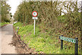
Horsewalk
A narrow road across Pevensey Levels to Wartling
Image: © Peter Jeffery
Taken: Unknown
0.24 miles