IMAGES TAKEN NEAR TO
Station Road, BATTLE, TN33 9DB
Introduction
This page details the photographs taken nearby to Station Road, TN33 9DB by members of the Geograph project.
The Geograph project started in 2005 with the aim of publishing, organising and preserving representative images for every square kilometre of Great Britain, Ireland and the Isle of Man.

There are currently over 7.5m images from over14,400 individuals and you can help contribute to the project by visiting https://www.geograph.org.uk
Image Map
Images are licensed for reuse under creativecommons.org/licenses/by-sa/2.0
Notes
- Clicking on the map will re-center to the selected point.
- The higher the marker number, the further away the image location is from the centre of the postcode.
Image Listing (124 Images Found)
Images are licensed for reuse under creativecommons.org/licenses/by-sa/2.0
Image
Details
Distance
1
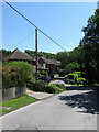
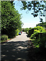
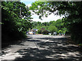
Station Road
Built in 1902 to serve the newly opened Crowhurst station. Since then piecemeal development has occurred on each side of the road.
Image: © Simon Carey
Taken: 14 Jun 2009
0.05 miles
2
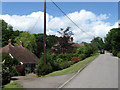
Station Road
Houses near Crowhurst station. Station Road was built in 1902 to serve the newly opened station and has developed piecemeal over the years.
Image: © Simon Carey
Taken: 14 Jun 2009
0.07 miles
4
Craig Close
Part of the cul-de-sac has been on the former platform bay of Crowhurst station. Viewed from the junction with Station Road.
Image: © Simon Carey
Taken: 14 Jun 2009
0.14 miles
7
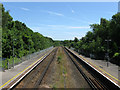
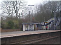
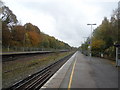
Crowhurst Station
The Tunbridge Wells-Hastings line was opened by the South East Railway company in 1852 the only one it ran in Sussex in competition with the London, Brighton & South Coast Railway. All stations opened with the line except this one which appeared in 1902 when the SER built a new line running from south of this station to the rapidly expanding resort of Bexhill. Originally named Crowhurst Junction the station had four sets of tracks to allow the fast Hastings expresses to speed through the station without having to move branch traffic. In addition the station had further bays on each platform for use of a connecting service. However, Bexhill remained loyal to the LBSCR and its coastway line and the branch soon failed to make money and was eventually closed in 1964. Crowhurst survived but lost two sets off tracks explaining the wide gap in the middle of the current ones and both bays now fenced off on the far edge of each platform. Viewed from the footbridge over the station.
Image: © Simon Carey
Taken: 14 Jun 2009
0.16 miles
8
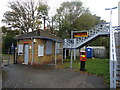
Crowhurst Station
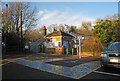
Viewed from Station Road, the access road built along with the station in 1902. The original station building was demolished in 1985 leaving just a former lamp room to serve as a booking office. The only other survivor of the demolition was the footbridge part of which can be seen beyond the booking office.
Image: © Simon Carey
Taken: 14 Jun 2009
0.16 miles
9
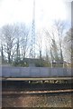
Telecommunications Mast, Crowhurst Station
Image: © N Chadwick
Taken: 11 Mar 2011
0.16 miles