IMAGES TAKEN NEAR TO
Crowhurst Road, BATTLE, TN33 9BT
Introduction
This page details the photographs taken nearby to Crowhurst Road, TN33 9BT by members of the Geograph project.
The Geograph project started in 2005 with the aim of publishing, organising and preserving representative images for every square kilometre of Great Britain, Ireland and the Isle of Man.

There are currently over 7.5m images from over14,400 individuals and you can help contribute to the project by visiting https://www.geograph.org.uk
Image Map
Images are licensed for reuse under creativecommons.org/licenses/by-sa/2.0
Notes
- Clicking on the map will re-center to the selected point.
- The higher the marker number, the further away the image location is from the centre of the postcode.
Image Listing (17 Images Found)
Images are licensed for reuse under creativecommons.org/licenses/by-sa/2.0
Image
Details
Distance
3
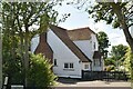
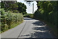
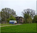
The White Cottage, Crowhurst Road
Weather-boarded cottage built at right angles to the lane dating from the 19th century.
Image: © Simon Carey
Taken: 28 Oct 2019
0.03 miles
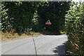
7
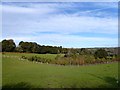
Coney Clappers
The name of the field according to Catsfield's 1839 tithe map located to the north of Crowhurst Road.
Image: © Simon Carey
Taken: 28 Oct 2019
0.17 miles
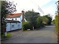
8
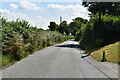
West Cottage/East Cottage, Crowhurst Road
Built in the 1930s.
Image: © Simon Carey
Taken: 30 Apr 2023
0.20 miles
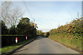
9
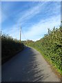
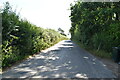
Crowhurst Road
Catsfield Road becomes Crowhurst Road just beyond Nashes Farmhouse with the lane forming the parish boundary between Crowhurst on the left and Catsfield to the right as far Fordlands Farm.
Image: © Simon Carey
Taken: 28 Oct 2019
0.20 miles