IMAGES TAKEN NEAR TO
Old Tower Walk, BATTLE, TN33 9BQ
Introduction
This page details the photographs taken nearby to Old Tower Walk, TN33 9BQ by members of the Geograph project.
The Geograph project started in 2005 with the aim of publishing, organising and preserving representative images for every square kilometre of Great Britain, Ireland and the Isle of Man.

There are currently over 7.5m images from over14,400 individuals and you can help contribute to the project by visiting https://www.geograph.org.uk
Image Map
Images are licensed for reuse under creativecommons.org/licenses/by-sa/2.0
Notes
- Clicking on the map will re-center to the selected point.
- The higher the marker number, the further away the image location is from the centre of the postcode.
Image Listing (36 Images Found)
Images are licensed for reuse under creativecommons.org/licenses/by-sa/2.0
Image
Details
Distance
1
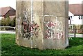
Graffiti on water tower by Darvel Down
Note also the lightning conductor.
Image: © Patrick Roper
Taken: 6 Apr 2010
0.04 miles
2
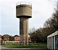
Water tower, Darvel Down
The land on which this concrete water tower stands doubles as a children's playpark.
Image: © Patrick Roper
Taken: 6 Apr 2010
0.04 miles
3
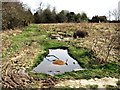
Rough land on Darvel Down
Children have dug shallow pools on this abandoned field at Darvel Down, Netherfield.
Image: © Patrick Roper
Taken: 6 Apr 2010
0.05 miles
5
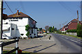
The White Hart Inn, Netherfield
On the B2096. Closed on mondays.
Image: © Robin Webster
Taken: 16 Apr 2007
0.06 miles
6
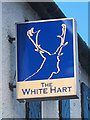
The White Hart sign
Sign for Image, a pub on Battle Road.
Image: © Oast House Archive
Taken: 22 Jul 2011
0.07 miles
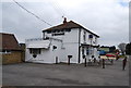
9
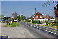
B2096, Netherfield
Near left is the car park of the White Hart Inn.
Image: © Robin Webster
Taken: 16 Apr 2007
0.08 miles
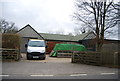
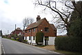
10
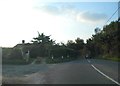
Entrance to house on the B2096, Netherfield
Image: © David Howard
Taken: 3 Sep 2012
0.10 miles