IMAGES TAKEN NEAR TO
Potmans Lane, BATTLE, TN33 9BJ
Introduction
This page details the photographs taken nearby to Potmans Lane, TN33 9BJ by members of the Geograph project.
The Geograph project started in 2005 with the aim of publishing, organising and preserving representative images for every square kilometre of Great Britain, Ireland and the Isle of Man.

There are currently over 7.5m images from over14,400 individuals and you can help contribute to the project by visiting https://www.geograph.org.uk
Image Map (Loading...)


Getting Data...Please wait
Leaflet Map data © OpenStreetMap
Images are licensed for reuse under creativecommons.org/licenses/by-sa/2.0
Notes
- Clicking on the map will re-center to the selected point.
- The higher the marker number, the further away the image location is from the centre of the postcode.
Image Listing (7 Images Found)
Images are licensed for reuse under creativecommons.org/licenses/by-sa/2.0
Image
Details
Distance
2

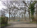
Daffodils by Potman's Lane
A considerable length of the verge is planted with daffodils, apparently associated with the paddocks on the right.
Image: © Robin Webster
Taken: 10 Mar 2014
0.08 miles
4
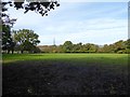
Lower Pit Field
The name of the field according to Catsfield's 1839 tithe map located to the north of Spratts Lane.
Image: © Simon Carey
Taken: 28 Oct 2019
0.16 miles
5
Lower Pit Field
The name of the field according to Catsfield's 1839 tithe map bounded to the south by Spratts Lane.
Image: © Simon Carey
Taken: 30 Apr 2023
0.16 miles
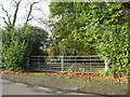
6
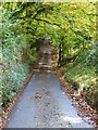
Spratts Lane
Narrow lane connecting Watermill lane at Henley's Down to Potmans Lane. Here it drops to cross an unnamed tributary of Watermill Stream with Spratts Wood to the left.
Image: © Simon Carey
Taken: 28 Oct 2019
0.24 miles
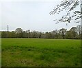
7
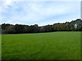
Stubb Field
The name of the field according to Catsfield's 1839 tithe map located to the north of Spratts Lane.
Image: © Simon Carey
Taken: 28 Oct 2019
0.24 miles