IMAGES TAKEN NEAR TO
Church Road, BATTLE, TN33 9BG
Introduction
This page details the photographs taken nearby to Church Road, TN33 9BG by members of the Geograph project.
The Geograph project started in 2005 with the aim of publishing, organising and preserving representative images for every square kilometre of Great Britain, Ireland and the Isle of Man.

There are currently over 7.5m images from over14,400 individuals and you can help contribute to the project by visiting https://www.geograph.org.uk
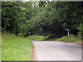
Image Map
Images are licensed for reuse under creativecommons.org/licenses/by-sa/2.0
Notes
- Clicking on the map will re-center to the selected point.
- The higher the marker number, the further away the image location is from the centre of the postcode.
Image Listing (71 Images Found)
Images are licensed for reuse under creativecommons.org/licenses/by-sa/2.0
Image
Details
Distance
1
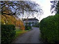
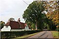
The Old Rectory, Church Road
Located to the south-west of the parish church the former rectory was built in the 18th century.
Image: © Simon Carey
Taken: 28 Oct 2019
0.01 miles
2
The Old Rectory
Grade II listed.
Image: © Oast House Archive
Taken: 26 Sep 2020
0.01 miles
3
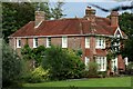
Lantern Cottage, Church Road
Weatherboarded cottage dating from the 18th century.
Image: © Simon Carey
Taken: 28 Oct 2019
0.05 miles
4
Lantern Cottage
Grade II listed. Road towards Catsfield.
Image: © Oast House Archive
Taken: 26 Sep 2020
0.05 miles
5
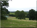
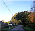
Mature trees by Catsfield Old Rectory
A new tennis court being put in.
Image: © Jonathan Billinger
Taken: 7 Jun 2007
0.06 miles
6
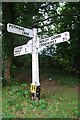
Direction Sign - Signpost by Church Lane, Catsfield
Black iron cap finial - 3 arms; East Sussex wood by the UC road, in parish of Catsfield (Rother District), Church Road, on verge opposite junction of Potman's Lane with Church Road.
Surveyed
Milestone Society National ID: SX_TQ7313
Image: © Milestone Society
Taken: Unknown
0.07 miles
7
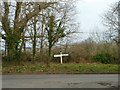
Signpost at the junction
Potman's Lane meets Church Road, right and left. The church concerned is at Catsfield, some way to the left.
Image: © Robin Webster
Taken: 10 Mar 2014
0.07 miles
8
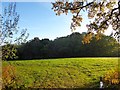
Brown Meadow
The name of the field according to Catsfield's 1839 tithe map located to the east of Church Road and west of Crowland Wood.
Image: © Simon Carey
Taken: 28 Oct 2019
0.07 miles
9
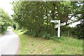
Signpost at junction of Potmans Lane
Image: © Julian P Guffogg
Taken: 21 Jun 2009
0.08 miles