IMAGES TAKEN NEAR TO
Forewood Lane, BATTLE, TN33 9AB
Introduction
This page details the photographs taken nearby to Forewood Lane, TN33 9AB by members of the Geograph project.
The Geograph project started in 2005 with the aim of publishing, organising and preserving representative images for every square kilometre of Great Britain, Ireland and the Isle of Man.

There are currently over 7.5m images from over14,400 individuals and you can help contribute to the project by visiting https://www.geograph.org.uk
Image Map
Images are licensed for reuse under creativecommons.org/licenses/by-sa/2.0
Notes
- Clicking on the map will re-center to the selected point.
- The higher the marker number, the further away the image location is from the centre of the postcode.
Image Listing (60 Images Found)
Images are licensed for reuse under creativecommons.org/licenses/by-sa/2.0
Image
Details
Distance
1
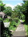
Cedardale
Small house tucked away off Forewood Lane next to the footpath to Crowhurst station.
Image: © Simon Carey
Taken: 14 Jun 2009
0.11 miles
2

Forewood Lane
Heading north from Crowhurst towards the A2100.
Image: © Robin Webster
Taken: 4 May 2019
0.13 miles
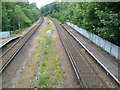
4
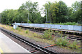
Crowhurst Station
Platform 1 to left and 2 to right.
Image: © Oast House Archive
Taken: 24 Apr 2011
0.13 miles
6
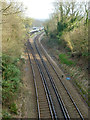
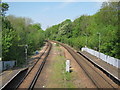
Next stop Crowhurst
The Tonbridge to Hastings line winds its way through the High Weald.
Image: © Robin Webster
Taken: 10 Mar 2014
0.13 miles
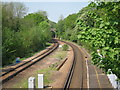
7
View from the footbridge at Crowhurst station
The line from Tonbridge to Tunbridge Wells was opened by the South Eastern Railway on 19th September 1845. The extension from Tunbridge Wells to Robertsbridge was opened on 1st September 1851, from Robertsbridge to Battle on 1st January 1852, and from Battle to St Leonard’s on 1st February 1853.
This is the only station between Tunbridge Wells and St Leonard's which was not designed by the company's architect William Tress. The reason was that although the section of the Hastings line through Crowhurst was completed in 1852, no station existed at this location until the South Eastern & Chatham Railway built a branch line to Bexhill West in 1902. This left the main route just south-east of the present station.
Crowhurst served as a junction station, with Up and Down through platforms and a bay platform at the southern end of each until closure of the Bexhill West branch in 1964. Most of the station buildings were then demolished - see http://www.geograph.org.uk/photo/3338314 This is the view from the footbridge looking up the line.
Image: © Marathon
Taken: 1 Jul 2013
0.13 miles
8
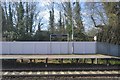
Hastings Line through Crowhurst
Arched brick road bridge on Forewood Lane seen ahead.
Image: © Oast House Archive
Taken: 24 Apr 2011
0.14 miles

10
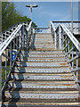
Footbridge at Crowhurst Station
Image: © Oast House Archive
Taken: 24 Apr 2011
0.14 miles