IMAGES TAKEN NEAR TO
The Coppice, BATTLE, TN33 0UJ
Introduction
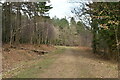
This page details the photographs taken nearby to The Coppice, TN33 0UJ by members of the Geograph project.
The Geograph project started in 2005 with the aim of publishing, organising and preserving representative images for every square kilometre of Great Britain, Ireland and the Isle of Man.

There are currently over 7.5m images from over14,400 individuals and you can help contribute to the project by visiting https://www.geograph.org.uk
Image Map (Loading...)


Getting Data...Please wait
Leaflet Map data © OpenStreetMap
Images are licensed for reuse under creativecommons.org/licenses/by-sa/2.0
Notes
- Clicking on the map will re-center to the selected point.
- The higher the marker number, the further away the image location is from the centre of the postcode.
Image Listing (6 Images Found)
Images are licensed for reuse under creativecommons.org/licenses/by-sa/2.0
Image
Details
Distance
1
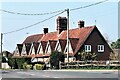
Houses by Hastings Road, B2100 at Starr's Green
An interesting row of triangular gables.
Image: © Patrick Roper
Taken: 25 Mar 2022
0.18 miles
6

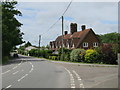
Confirmation of arrival sign for Battle by Hastings Road, B2100
Image: © Patrick Roper
Taken: 25 Mar 2022
0.25 miles