IMAGES TAKEN NEAR TO
Powdermill Lane, BATTLE, TN33 0SZ
Introduction
This page details the photographs taken nearby to Powdermill Lane, TN33 0SZ by members of the Geograph project.
The Geograph project started in 2005 with the aim of publishing, organising and preserving representative images for every square kilometre of Great Britain, Ireland and the Isle of Man.

There are currently over 7.5m images from over14,400 individuals and you can help contribute to the project by visiting https://www.geograph.org.uk
Image Map (Loading...)


Getting Data...Please wait
Leaflet Map data © OpenStreetMap
Images are licensed for reuse under creativecommons.org/licenses/by-sa/2.0
Notes
- Clicking on the map will re-center to the selected point.
- The higher the marker number, the further away the image location is from the centre of the postcode.
Image Listing (17 Images Found)
Images are licensed for reuse under creativecommons.org/licenses/by-sa/2.0
Image
Details
Distance
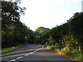
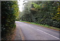
2
Junction of Powdermill Lane with B2204
Image: © Julian P Guffogg
Taken: 26 Apr 2009
0.15 miles
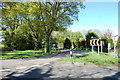
3
Catsfield Road at the junction of Powdermill Lane
Image: © David Howard
Taken: 3 Sep 2012
0.15 miles
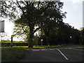
9
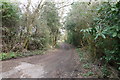
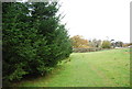
Track to Starcroft Farm
On the 1066 Country Walk heading towards Battle
Image: © Tim Heaton
Taken: 27 Apr 2013
0.18 miles
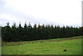
10
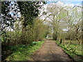
1066 Country Walk leaving the B2204
The long distance footpath heading east and away from the B2204 at Catsfield, heading towards Battle.
Image: © Chris Heaton
Taken: 27 Apr 2013
0.19 miles