IMAGES TAKEN NEAR TO
Moat Lane, BATTLE, TN33 0RZ
Introduction
This page details the photographs taken nearby to Moat Lane, TN33 0RZ by members of the Geograph project.
The Geograph project started in 2005 with the aim of publishing, organising and preserving representative images for every square kilometre of Great Britain, Ireland and the Isle of Man.

There are currently over 7.5m images from over14,400 individuals and you can help contribute to the project by visiting https://www.geograph.org.uk
Image Map (8 Images)


Getting Data...Please wait
Leaflet Map data © OpenStreetMap
Images are licensed for reuse under creativecommons.org/licenses/by-sa/2.0
Notes
- Clicking on the map will re-center to the selected point.
- The higher the marker number, the further away the image location is from the centre of the postcode.
Image Listing (8 Images Found)
Images are licensed for reuse under creativecommons.org/licenses/by-sa/2.0
Image
Details
Distance

2
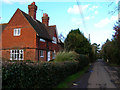
Moat Farmhouse, Moat Lane
Part of the parish of Westfield, there is a straggling community of houses along this lane.
Image: © Simon Carey
Taken: 21 Feb 2007
0.06 miles

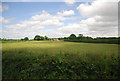

7
Playing fields near Claremont School
Image: © Julian P Guffogg
Taken: 8 Mar 2009
0.25 miles
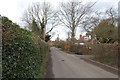
8
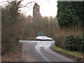
Junction with Moat Lane onto Ebden's Hill
Image: © Oast House Archive
Taken: 2 Jan 2009
0.25 miles