IMAGES TAKEN NEAR TO
Brede Lane, BATTLE, TN33 0PQ
Introduction
This page details the photographs taken nearby to Brede Lane, TN33 0PQ by members of the Geograph project.
The Geograph project started in 2005 with the aim of publishing, organising and preserving representative images for every square kilometre of Great Britain, Ireland and the Isle of Man.

There are currently over 7.5m images from over14,400 individuals and you can help contribute to the project by visiting https://www.geograph.org.uk
Image Map (Loading...)


Getting Data...Please wait
Leaflet Map data © OpenStreetMap
Images are licensed for reuse under creativecommons.org/licenses/by-sa/2.0
Notes
- Clicking on the map will re-center to the selected point.
- The higher the marker number, the further away the image location is from the centre of the postcode.
Image Listing (57 Images Found)
Images are licensed for reuse under creativecommons.org/licenses/by-sa/2.0
Image
Details
Distance
1
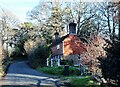
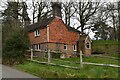
Mab's Cottage in Brede Lane, Sedlescombe
Image: © Patrick Roper
Taken: 10 Dec 2021
0.00 miles
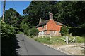

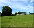
8
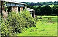
Part of Brede Barn Farm looking across the Brede Valley
Image: © Patrick Roper
Taken: 11 Jun 2022
0.07 miles
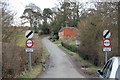
9
Warren Field
The name of the field according to Sedlescombe's 1841 tithe map with Brede Barn Farm at its northern end.
Image: © Simon Carey
Taken: 16 Aug 2023
0.07 miles