IMAGES TAKEN NEAR TO
Brede Lane, BATTLE, TN33 0PN
Introduction
This page details the photographs taken nearby to Brede Lane, TN33 0PN by members of the Geograph project.
The Geograph project started in 2005 with the aim of publishing, organising and preserving representative images for every square kilometre of Great Britain, Ireland and the Isle of Man.

There are currently over 7.5m images from over14,400 individuals and you can help contribute to the project by visiting https://www.geograph.org.uk
Image Map (Loading...)


Getting Data...Please wait
Leaflet Map data © OpenStreetMap
Images are licensed for reuse under creativecommons.org/licenses/by-sa/2.0
Notes
- Clicking on the map will re-center to the selected point.
- The higher the marker number, the further away the image location is from the centre of the postcode.
Image Listing (21 Images Found)
Images are licensed for reuse under creativecommons.org/licenses/by-sa/2.0
Image
Details
Distance
2
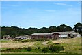
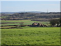
Lower Jacobs Farm
Modern barns to the south, older buildings to the north.
Image: © Simon Carey
Taken: 16 Aug 2023
0.08 miles

4

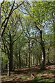
Little Brede Wood
Located south of Brede Lane.
Image: © Simon Carey
Taken: 16 Aug 2023
0.14 miles
6
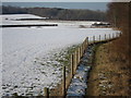
Lower Brook
The name of the field according to Brede's 1840 tithe map bounded by Horn's Wood to the east and Brede Lane to the south.
Image: © Simon Carey
Taken: 16 Aug 2023
0.15 miles
7

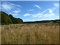
South Alder Field
The name of the field according to Brede's 1840 tithe map.
Image: © Simon Carey
Taken: 16 Aug 2023
0.16 miles
8
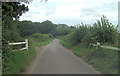
Footpath off Brede Lane
Footpath towards Powdermill Lane.
Image: © Oast House Archive
Taken: 11 Feb 2012
0.17 miles
9
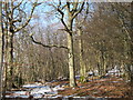
Horn's Wood
Woodland beside Brede Lane.
Image: © Oast House Archive
Taken: 11 Feb 2012
0.19 miles