IMAGES TAKEN NEAR TO
Whatlington Road, BATTLE, TN33 0ND
Introduction
This page details the photographs taken nearby to Whatlington Road, TN33 0ND by members of the Geograph project.
The Geograph project started in 2005 with the aim of publishing, organising and preserving representative images for every square kilometre of Great Britain, Ireland and the Isle of Man.

There are currently over 7.5m images from over14,400 individuals and you can help contribute to the project by visiting https://www.geograph.org.uk
Image Map
Images are licensed for reuse under creativecommons.org/licenses/by-sa/2.0
Notes
- Clicking on the map will re-center to the selected point.
- The higher the marker number, the further away the image location is from the centre of the postcode.
Image Listing (39 Images Found)
Images are licensed for reuse under creativecommons.org/licenses/by-sa/2.0
Image
Details
Distance
7
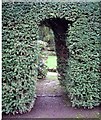
Entrance through yew hedge to topiary garden, Mill Lane
Image: © Patrick Roper
Taken: 14 Feb 2007
0.18 miles
8
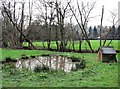
Pond and duck house in Line valley, Whatlington
Image: © Patrick Roper
Taken: 29 Jan 2007
0.18 miles
9
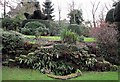
Steps with ferns in Whatlington topiary garden
The ferns are mostly hart's-tongue (Asplenium scolopendrium)
Image: © Patrick Roper
Taken: 14 Feb 2007
0.19 miles
10
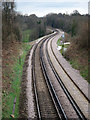
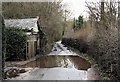
Hastings Line near Wood's Farm
Between Robertsbridge and Battle stations.
Image: © Oast House Archive
Taken: 4 Apr 2015
0.19 miles