IMAGES TAKEN NEAR TO
Caldbec Hill, BATTLE, TN33 0JR
Introduction
This page details the photographs taken nearby to Caldbec Hill, TN33 0JR by members of the Geograph project.
The Geograph project started in 2005 with the aim of publishing, organising and preserving representative images for every square kilometre of Great Britain, Ireland and the Isle of Man.

There are currently over 7.5m images from over14,400 individuals and you can help contribute to the project by visiting https://www.geograph.org.uk
Image Map (Loading...)


Getting Data...Please wait
Leaflet Map data © OpenStreetMap
Images are licensed for reuse under creativecommons.org/licenses/by-sa/2.0
Notes
- Clicking on the map will re-center to the selected point.
- The higher the marker number, the further away the image location is from the centre of the postcode.
Image Listing (71 Images Found)
Images are licensed for reuse under creativecommons.org/licenses/by-sa/2.0
Image
Details
Distance
4
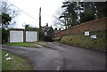
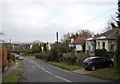
Edwardian Cottage, Caldbec Hill
The plaque on the wall suggests this cottage was built in 1904.
Image: © N Chadwick
Taken: 19 Feb 2009
0.04 miles
5
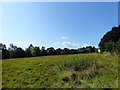
Town Field
The name of the field according to Battle's 1859 tithe map located on Caldbec Hill to the east of Whatlington Road.
Image: © Simon Carey
Taken: 20 Aug 2019
0.04 miles
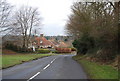
6
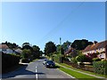
Whatlington Road, Battle
Climbing Caldbec Hill on its way to the town centre.
Image: © Simon Carey
Taken: 20 Aug 2019
0.07 miles
10
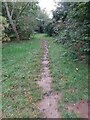
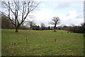
Footpath through an Orchard
Public footpath through an orchard near Caldbec Hill just north of Battle in East Sussex.
Image: © John P Reeves
Taken: 18 Oct 2021
0.10 miles