IMAGES TAKEN NEAR TO
Swallow Drive, BATTLE, TN33 0DY
Introduction
This page details the photographs taken nearby to Swallow Drive, TN33 0DY by members of the Geograph project.
The Geograph project started in 2005 with the aim of publishing, organising and preserving representative images for every square kilometre of Great Britain, Ireland and the Isle of Man.

There are currently over 7.5m images from over14,400 individuals and you can help contribute to the project by visiting https://www.geograph.org.uk
Image Map (Loading...)


Getting Data...Please wait
Leaflet Map data © OpenStreetMap
Images are licensed for reuse under creativecommons.org/licenses/by-sa/2.0
Notes
- Clicking on the map will re-center to the selected point.
- The higher the marker number, the further away the image location is from the centre of the postcode.
Image Listing (85 Images Found)
Images are licensed for reuse under creativecommons.org/licenses/by-sa/2.0
Image
Details
Distance
2
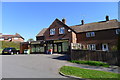
General Store, Coronation Gardens, Battle
Victuals for the 1066 Country Walk
Image: © Tim Heaton
Taken: 28 Apr 2013
0.07 miles
4

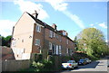
Houses in Coronation Gardens, Battle
Note solar panels on middle house.
Image: © Patrick Roper
Taken: 2 Feb 2022
0.07 miles
6

Back garden with cabbage palms, Marley Gardens
The cabbage palm, Cordyline australis, is clearly hardy here.
Image: © Patrick Roper
Taken: 25 Mar 2022
0.10 miles
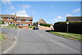
8

View west along Marley Gardens, Battle
Image: © Patrick Roper
Taken: 25 Mar 2022
0.11 miles

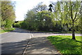
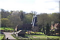
10

Blackfriars Oast off Marley Lane, Battle
Image: © Patrick Roper
Taken: 23 Aug 2006
0.12 miles